The Center BEYOND, has a well-accepted and validated recognition in the provision of research and operational services in the framework of the European Union's Global Monitoring for Environment and Security Program namely Copernicus (former GMES), and to the European Space Agency (ESA). The emphasis of the Center's activity is on Emergency Response (Copernicus/Emergency Management Support), monitoring and protection of the Marine and Atmospheric Environment, as well as applications of Agriculture, Renewable Energy, and Climate Change and its impact on quality of citizens' life (e.g. natural disasters).

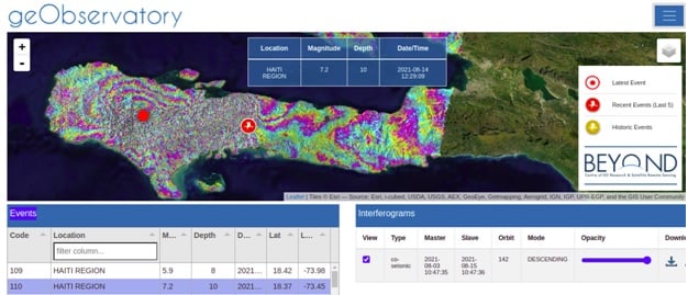
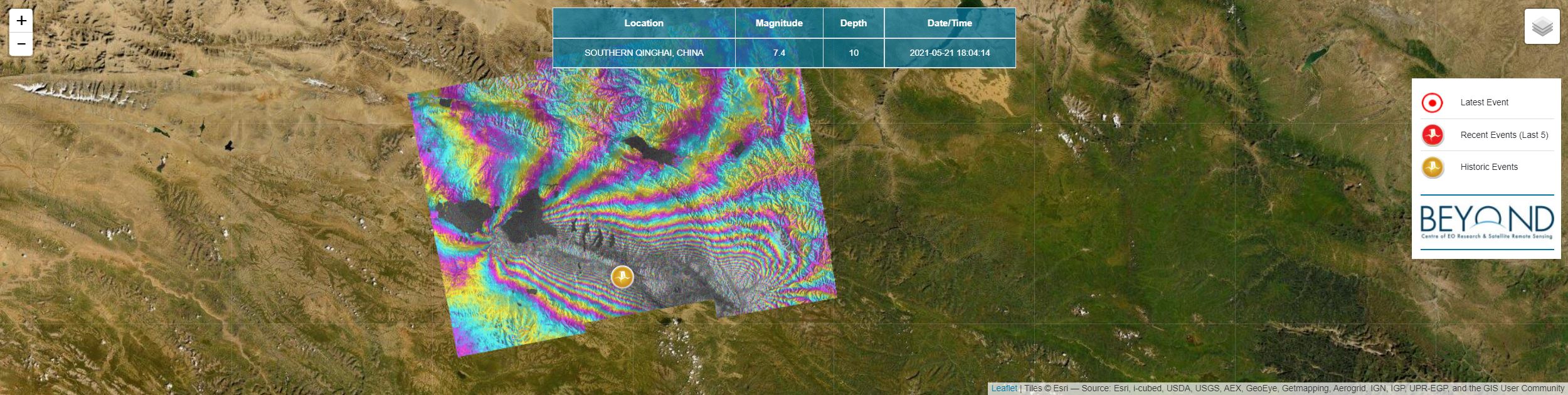
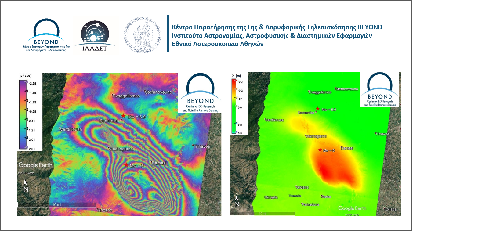
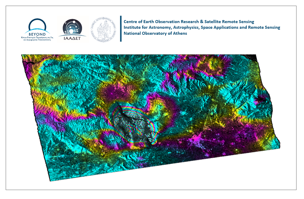
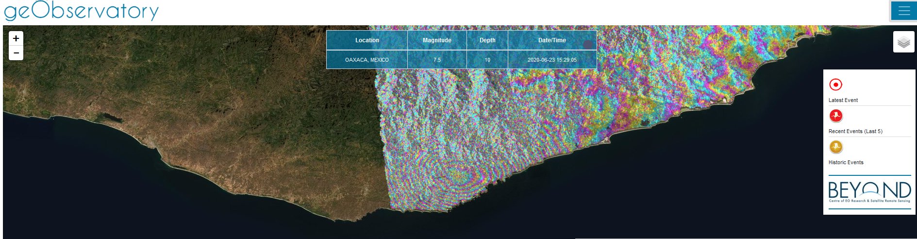
The BEYOND sub-systems FireHub, FloodHub, and GeoHub were developed for real-time delivery of space based services, for early detection, continuous monitoring, and management of natural disasters, the monitoring of active forest fires, flood events and seismic/volcanic risks, as well as damage assessments in rush and off-line mode. These services are routinely used by many environmental and civil protection organizations in Greece, and worldwide including EU bodies, namely the European Forest Fire Information System/EFFIS, the Global Fire Monitoring Center (GFMC), the European Copernicus/EMS Program, in a large number of Civil Protection Authorities in Europe, Africa, Latin America, Asia, and authorities as the Fire Brigade Body in Greece, the Directorate and Natural Environment Protection (Ministry of Environment), the Public Forestry Services, the Directorate for Planning and Disaster Response of the General Secretariat of Civil Protection, the Department for Natural Disasters Recovery (Min of Infrastructure and Transport), etc.

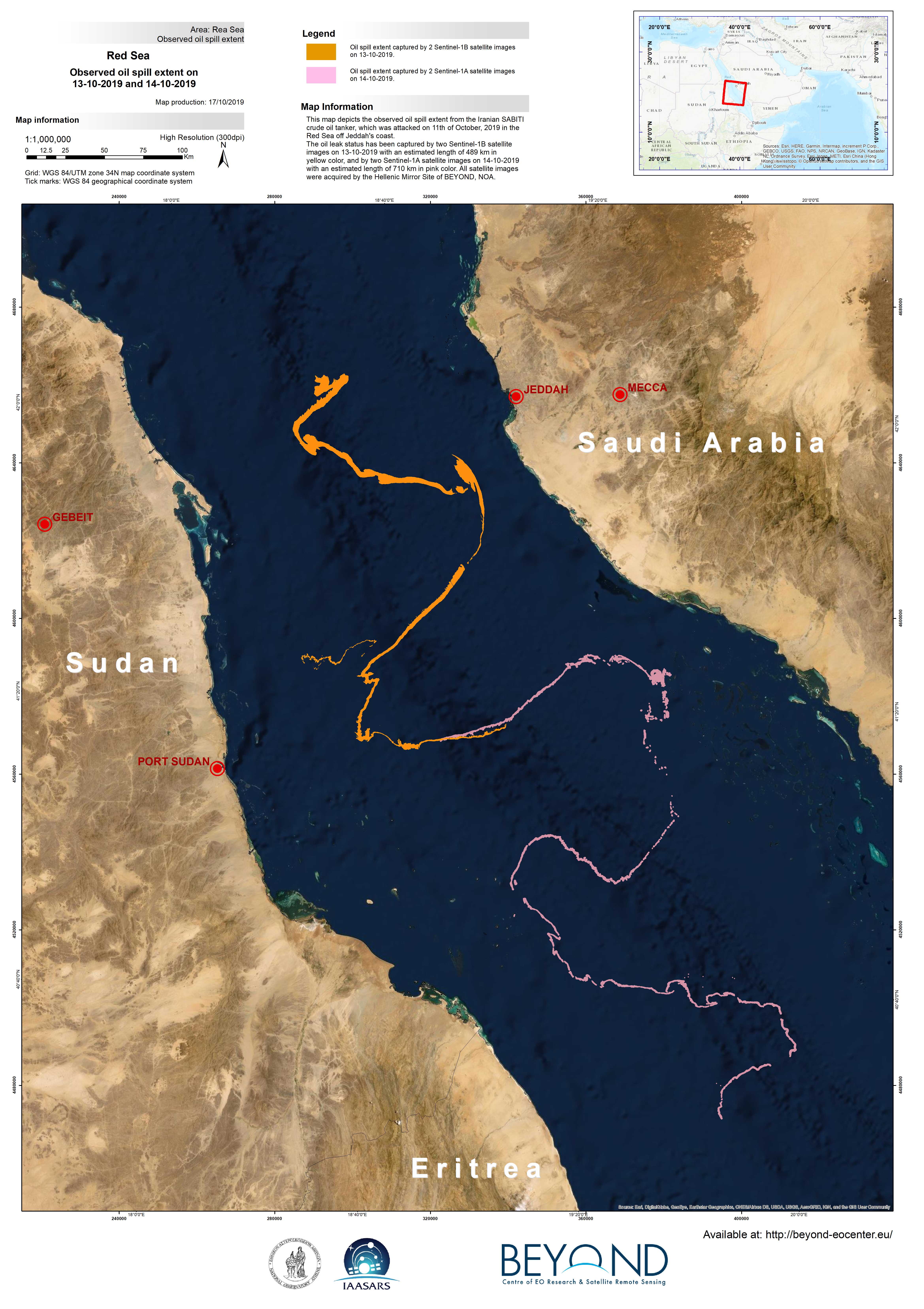
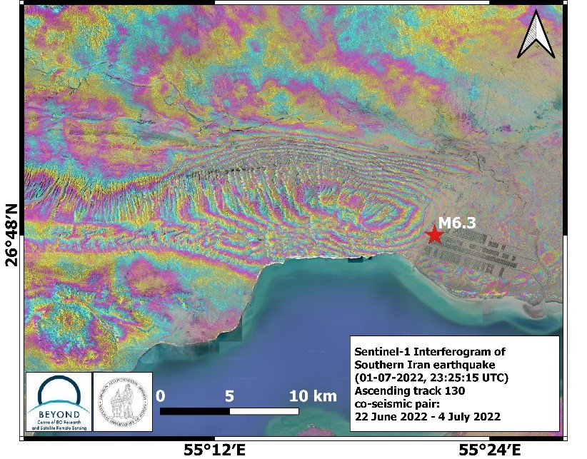
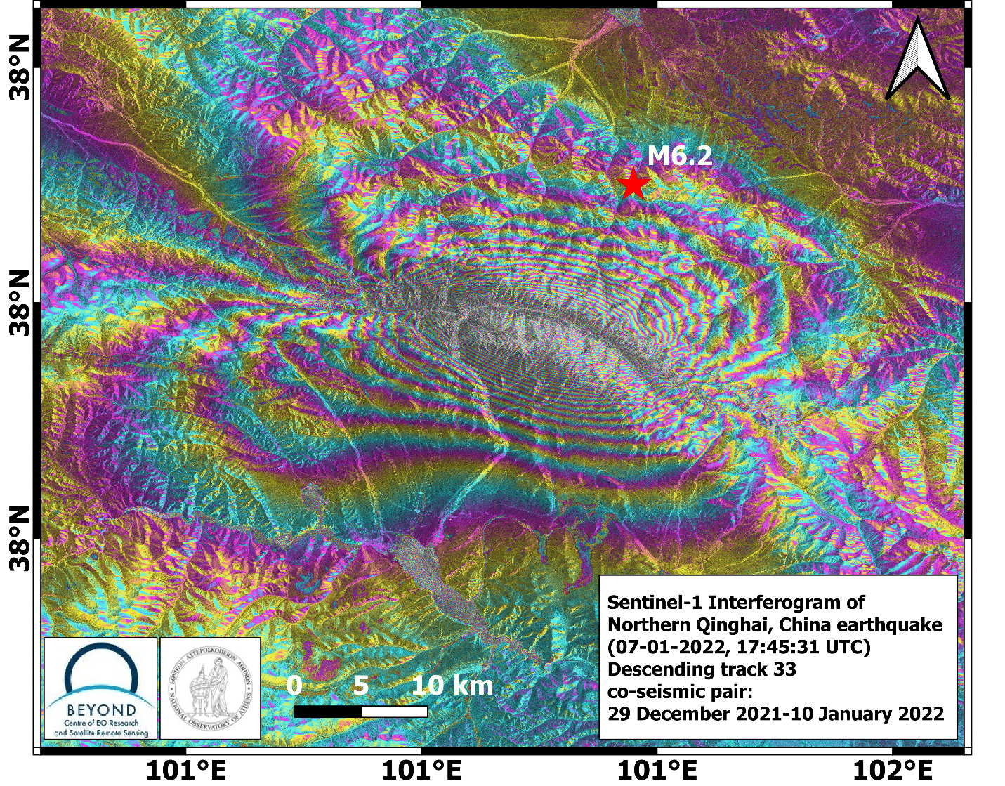
Indicatively, only over the period 2016-2018 the BEYOND Center has been activated through the Copernicus EMS program from more than 13 Civil Protection Authorities around the world, in order to address timely risk assessments across a wide range of natural disasters such as earthquakes, volcanoes, landslides, slope and coastal erosion, fires, floods, toxic gas emissions, smoke dispersion and industrial accidents.

The BEYOND Center has been selected by the EU to offer real-time satellite based active fire detection and fire-damage assessment services (FireHub) for the needs of the European Forest Fire Information System (EFFIS).

oilSplii temp portrait Final

BEYOND EO Center was mobilized to assess the spread of the oil spill in the Red Sea, and produced this map depicting the observed oil spill extent from the Iranian SABITI crude oil tanker, which was attacked on October 11th 2019 off Jeddah's coast.

The oil leak status has been captured by two Sentinel-1B satellite images on 13-10-2019 with an estimated length of 489 km in yellow color, and by two Sentinel-1A satellite images on 14-10-2019 with an estimated length of 710 km in pink color. All satellite images were acquired by the Hellenic Mirror Site of BEYOND, NOA.

It is undoubtedly a large disaster, rendering a severe contamination effect.

BEYOND will continue to monitor the oil spill for the next few days in order to detect changes and assess the level of marine pollution.

 iran

In July 1, 2022, 23:25:15 UTC, an M6.3 earthquake occurred in Southern Iran. Co-seismic deformation was mapped by the geObservatory service of BEYOND Center of Earth Observation Research and Satellite Remote Sensing of the National Observatory of Athens. The first co-seismic interferogram was produced with the use of two Sentinel-1 images of June 22, 2022 and July 4, 2022 of ascending satellite track 130. In the co-seismic interferogram, surface deformation induced by the seismic event is clearly presented bυ numerous fringes. 11 fringes can be detected. Each fringe corresponds to a ground deformation equal to 2.8 cm, resulting to an overall of almost 30 cm of ground deformation. All co-seismic and pre-seismic interferograms, associated with the event are freely available in the geObsevatory website (http://geobservatory.beyond-eocenter.eu/).

 china

On January 07, 2022, 17:45:31 UTC a strong earthquake of M6.2 occurred in Northern Qinghai, China. geObservatory service of BEYOND Center of Earth Observation Research and Satellite Remote Sensing of the National Observatory of Athens, was activated and detected co-seismic deformation induced by the seismic event. The first co-seismic interferogram, was generated from Sentinel-1 SLC images of descending track 33, of December 29, 2021 and January 10, 2022. Each fringe in the interferogram corresponds to ground deformation equal to 2.8 cm. All co-seismic and pre-seismic interferograms, associated with the event are freely available in the geObsevatory website (http://geobservatory.beyond-eocenter.eu/), which is updated with new interferograms as long as new Sentinel-1 satellite data becomes available at the Hellenic Mirror Site.

 HAITI

First co-seismic interferogram of Haiti region earthquake.
On August 14, 2021, 12:29:09 UTC a strong earthquake of M7.2, occurred in Haiti region. It was followed by a second seismic event of M5.9, on August 15, 2021, 03:20:45 UTC. The geObservatory service of BEYOND Center of Earth Observation Research and Satellite Remote Sensing of the National Observatory of Athens, was activated and mapped ground deformation in the affected region. Sentinel-1 SLC images of descending track 142, of August 3, 2021 and August 15, 2021, were used to produce the first co-seismic interferogram, where deformation of both seismic events is mapped. Each fringe in the interferogram corresponds to ground deformation equal to 2.8 cm. All co-seismic and pre-seismic interferograms, associated with the events are freely available in the geObsevatory website (http://geobservatory.beyond-eocenter.eu/). The website will be updated with new interferograms as long as new Sentinel-1 satellite data becomes available at the Hellenic Mirror Site.

20210521qinghai

First co-seismic interferograms, Southern Qinghai, China earthquake.

Picture1

The geObservatory service of BEYOND Center of Earth Observation Research and Satellite Remote Sensing of the National Observatory of Athens, was again activated on March 4, 2021, 18:38:17 UTC, to monitor a new strong earthquake, near Elassona city in Thessaly, with a magnitude of Mw=5.9. 

Η υπηρεσία geObservatory του Κέντρου Παρατήρησης της Γης και Δορυφορικής Τηλεπισκόπησης BEYOND του Εθνικού Αστεροσκοπείου Αθηνών, ενεργοποιήθηκε εκ νέου στις 4 Μαρτίου του 2021 στις 18:38:17 UTC, μετά τον νέο ισχυρό σεισμό, κοντά στην πόλη της Ελασσόνας, στην Θεσσαλία, με μέγεθος Mw=5.9.

LARISA FINAL EN

Interferogram of Týrnavos earthquake of March 3, 2021 10:16:07 UTC. The earthquake occurred on March 3, 2021 in 10:16:07 UTC, with a magnitude of Mw=6 in Richter scale, a focal depth of 7.8km and an epicenter in 16km South of Elassona city, according to the Institute of Geodynamics of the National Observatory of Athens.


 EbWWycxWoAARscO

First co-seismic ascending interferogram for the 2020.06.23, M7.4 Santa María Zapotitlán, earthquake in Mexico. All interferograms that cover the event are available to download from BEYOND’s geObservatory service: http://geobservatory.beyond-eocenter.eu.


nevada1

BEYOND’s geObservatory was activated automatically, and produced a series of co-seismic and pre-seismic interferograms, which are available for viewing and downloading at http://geobservatory.beyond-eocenter.eu/.


Copernicus EMS - Mapping provides all actors involved in the management of natural disasters, man-made emergency situations and humanitarian crises, with timely and accurate geospatial information derived from satellite remote sensing and completed by available in situ or open data sources. The information generated by the service can be used as supplied (e.g. as digital or printed map outputs). It may be further combined with other data sources (e.g. as digital feature sets in a geographic information system). In both cases it may support geospatial analysis and decision making processes of emergency managers. Copernicus EMS - Mapping is provided during all phases of the emergency management cycle, in two temporal modes, and free of charge for the users. It can be activated only by authorized users.

The infrastructure and excellence developed in the BEYOND Center of Excellence are actively involved in the provision of Risk & Recovery Mapping which consists of the on-demand provision of geospatial information in support of Emergency Management activities related to Emergency Support. This applies in particular to activities dealing with prevention, preparedness, disaster risk reduction and recovery phases. There are three broad product categories: Reference Maps, Pre-disaster Situation Maps and Post-disaster Situation Maps. The research developed in BEYOND, exploits satellite data and ingests fusions of geo-partial information and data in rush mode, when, where needed, for enhanced risk modelling and improved assessment of the expected disaster impacts.

The list of methodologies developed, adapted, validated, and used in BEYOND to address risk and recovery needs of the civil protection authorities worldwide are listed below (in more details in ANNEX III):

  • Seismic Methodologies: Seismic Hazard, Seismic Vulnerability, Seismic Vulnerability of Pipelines, Seismic Risk.
  • Lava Flow Methodologies: Lava Flow Hazard, Lava Flow Vulnerability, Lava Flow Risk.
  • Forest Fires Methodologies: Fire Damage Delineation & Burn Severity Grading, Damage/Biomass Loss Statistics, Forest Fire Hazard, Population & Assets Vulnerability to Forest Fires, Forest Fire Risk – Population, Assets and Transportation Network at risk.
  • Industrial Accidents Methodologies: Industrial Accidents Hazard, Industrial Accidents Exposure, Industrial Accidents Risk.
  • Tsunami Methodologies: Tsunami Hazard Assessment, Assets Vulnerability to Tsunami, Storm Surge Hazard Risk.
  • Soil Erosion Methodology: Soil Erosion Hazard.
  • Coastal Erosion Methodology: Coastal Erosion Vulnerability.
  • Ground Deformation Methodology: Ground Deformation Dynamics.
  • Landslides Methodology: Landslide Hazard, Landslide Vulnerability, Landslide Risk.
  • Subsidence and Landslide Methodology: Subsidence and Landslide Risk.
  • Floods Methodology: Flood Delineation at peak conditions, Flood Depth at peak conditions, Flood Damage Assessment, Flood Hazard, Flood Vulnerability, Flood Risk, Flash Flood Hazard triggered by earthquakes, Flash Flood Risk triggered by earthquakes.
  • Disruption of Transportation Networks Methodology: Vulnerability of Disruption of Transportation Networks.

Up to now the BEYOND Center has been activated in the framework of the COPERNICUS EMERGENCY MANAGEMENT SERVICE in the following worldwide disaster risk and recovery cases :

An overview of missons in which UAVs were used to record raw data flighting above the affected from natural disasters areas; and to map and to assess the damages caused.