Template Landscape SmokeFire22 sithonia

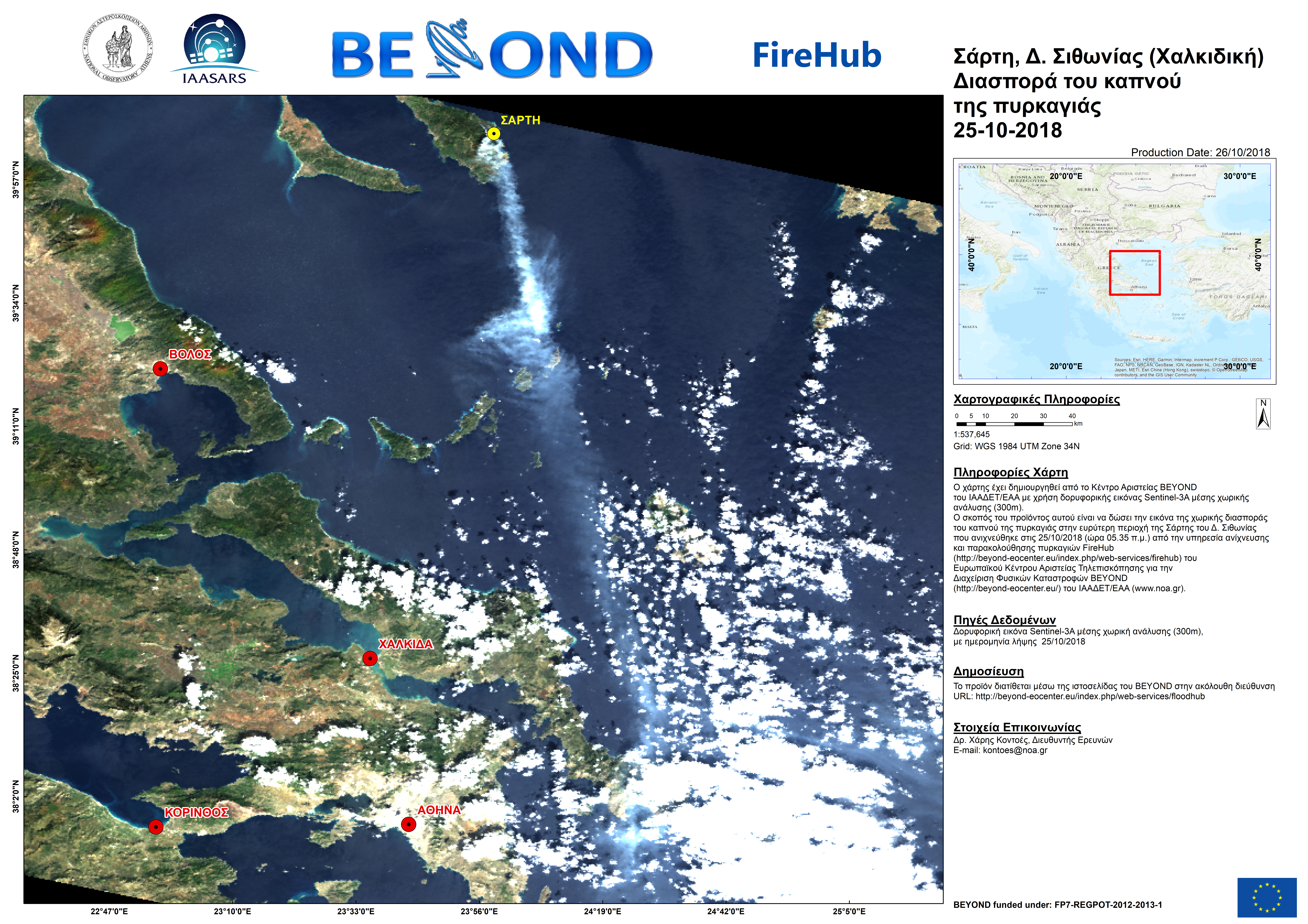
Ο παρακάτω χάρτης έχει δημιουργηθεί από το Κέντρο Αριστείας BEYOND του ΙΑΑΔΕΤ/ΕΑΑ με χρήση δορυφορικής εικόνας Sentinel-3A μέσης χωρικής ανάλυσης (300m).

Ο σκοπός του προϊόντος αυτού είναι να δώσει την εικόνα της χωρικής διασποράς του καπνού της πυρκαγιάς στην ευρύτερη περιοχή της Σάρτης του Δ. Σιθωνίας που ανιχνεύθηκε στις 25/10/2018 (ώρα 05.35 π.μ.) από την υπηρεσία ανίχνευσης και παρακολούθησης πυρκαγιών FireHubτου Ευρωπαϊκού Κέντρου Αριστείας Τηλεπισκόπησης για την Διαχείριση Φυσικών Καταστροφών BEYOND του ΙΑΑΔΕΤ/ΕΑΑ (www.noa.gr).


The BEYOND Centre of Excellence created a map using images from Sentinel-3A based on 300m resolution. This image presents the fire smoke dispersion from the fire of 25 October in Sithonia -Chalkidiki.

Sithonia v3 optimized

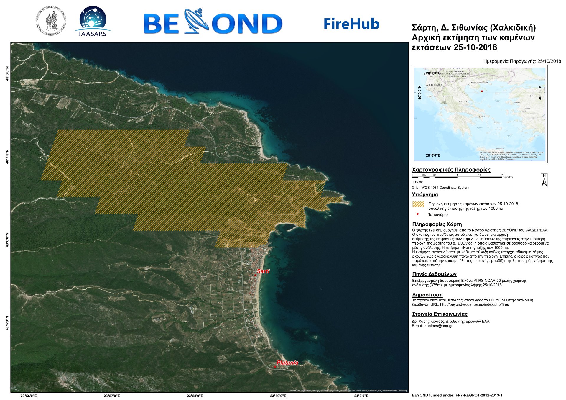
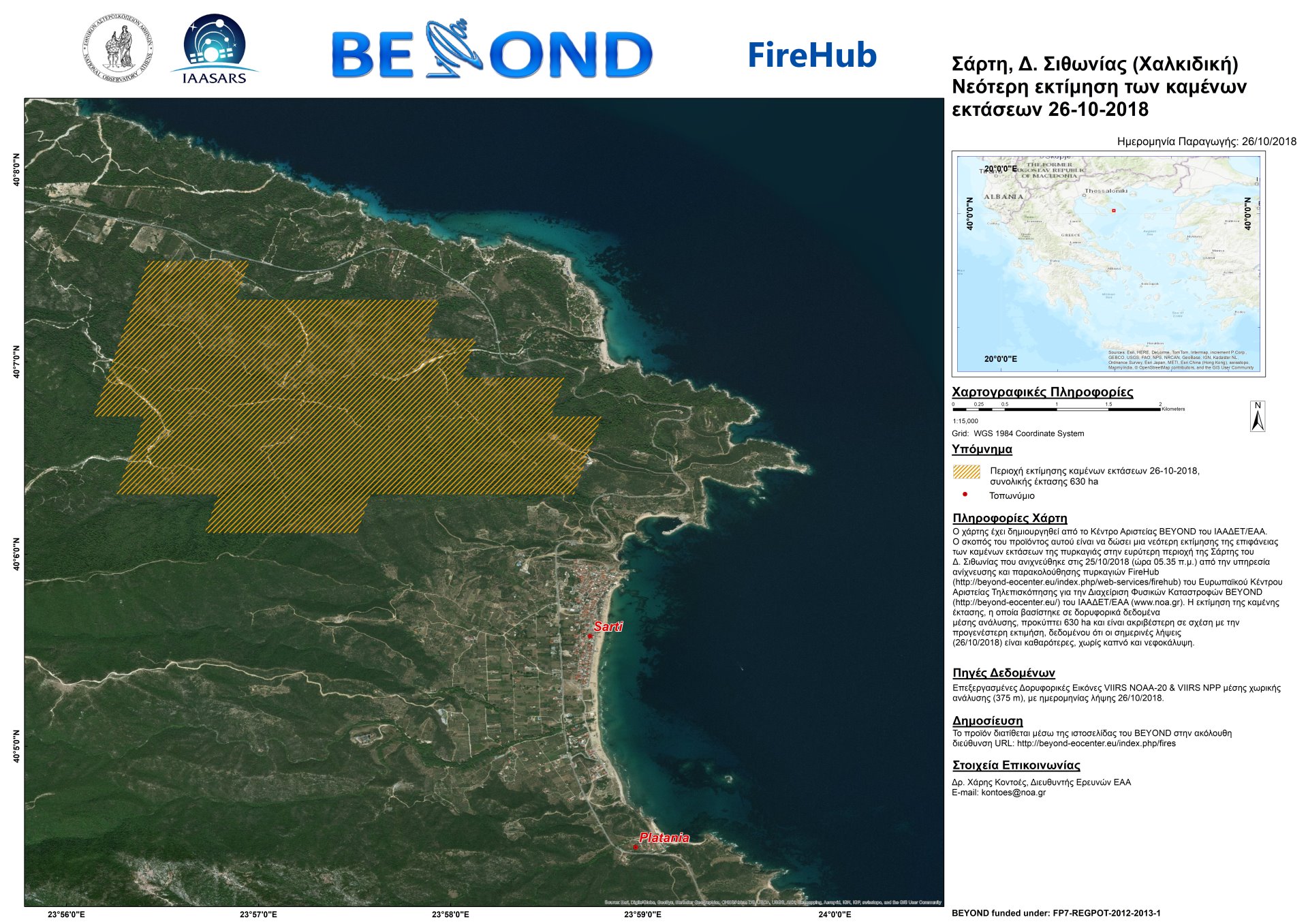
Με βάση την πρώτη εκτίμηση της καμένης έκτασης σε ανάλυση 375 μ. από τον δορυφορικό αισθητήρα VIIRS και συγκεκριμένα από τον δορυφόρο Suomi NPP και NOAA-20 η καμένη έκταση υπολογίζεται περίπου στα 1000ha. Η εκτίμηση ανακοινώνεται με κάθε επιφύλαξη, καθώς υπάρχει αδυναμία λήψης εικόνων χωρίς νεφοκάλυψη πάνω από την περιοχή. Επίσης, ο ίδιος ο καπνός που παράγεται από την καύσιμη ύλη της περιοχής εμποδίζει τη λεπτομερή εκτίμηση της καμένης έκτασης.

Μόλις έχουμε δορυφορικές εικόνες με λιγότερη νεφοκάλυψη θα επανέλθουμε με νεότερες και ακριβέστερες εκτιμήσεις.


A first estimate of the burned areas in Sithonia Chalkidiki is estimated at about 1000 ha, based on the 375 meters resolution VIIRS sensor data, on board the Suomi NPP and NOAA-20 satellites. This is a first rough approximation since smoke plumes from the ongoing fire prevents a precise mapping of the burnt area perimeter.

Stay tuned as today we will update this first estimation based on new satellite acquisitions.

20180730 leptomereis ektimisi

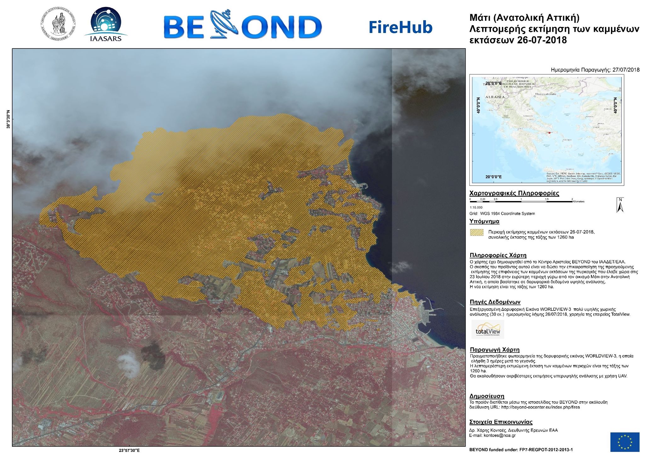
Το Κέντρο Διαχείρισης Φυσικών Καταστροφών BEYOND του Ινστιτούτου Αστρονομίας, Αστροφυσικής, Διαστημικών Εφαρμογών & Τηλεπισκόπησης (ΙΑΑΔΕΤ) του Εθνικού Αστεροσκοπείου Αθηνών (ΕΑΑ) δημοσιεύει σήμερα επικαιροποιημένο χάρτη με λεπτομερή εκτίμηση των καμμένων εκτάσεων στην ευρύτερη περιοχή γύρω από τον οικισμό Μάτι (Ανατολική Αττική) με χρήση δορυφορικής τηλεπισκόπησης, με εκτιμώμενη έκταση της τάξης των 1260 ha.

Η εκτίμηση αυτή έγινε κατόπιν επεξεργασίας της δορυφορικής εικόνας WORLDVIEW-3 πολύ υψηλής χωρικής ανάλυσης (30 εκ.), η οποία ελήφθη 3 ημέρες μετά το γεγονός, χορηγία της εταιρείας TotalView.

Ταυτόχρονα το Κέντρο BEYOND συνεχίζει την χαρτογράφηση με συστήματα Drones / UAV υπερυψηλής χωρικής ανάλυσης, προκειμενου να παρέχει πολύ λεπτομερείς χάρτες αποτιμήσης της ζημιάς σε επίπεδο μεμονωμένης ιδιοκτησίας.

Στις δύσκολες αυτές μέρες, οι σκέψεις μας είναι με τα θύματα και τους συνανθρώπους μας που έχουν πληγεί από την ανείπωτη αυτή τραγωδία, και οι υπηρεσίες μας είναι στη διάθεση της πολιτείας συμβάλλοντας κατά το δυνατόν στη διαχείριση της τεράστιας καταστροφής.

Στοιχεία επικοινωνίας: Δρ. Χάρης Κοντοές, Διευθυντής Ερευνών Ε.Α.Α., This email address is being protected from spambots. You need JavaScript enabled to view it.


Η λεπτομερής χαρτογράφηση της καμένης έκτασης στην περιοχή του Σοφικού Κορινθίας προήλθε από την επεξεργασία δορυφορικών δεδομένων Sentinel-2A.

Η λεπτομερής χαρτογράφηση της καμένης έκτασης στην περιοχή του Καλάμου προήλθε από την επεξεργασία δορυφορικών δεδομένων Sentinel-2B.

Η λεπτομερής χαρτογράφηση της καμένης έκτασης στα Κύθηρα προήλθε από την επεξεργασία δορυφορικών δεδομένων Sentinel-2A.

Η λεπτομερής χαρτογράφηση της καμένης έκτασης στην περιοχή του Σκουταρίου Λακωνίας προήλθε από την επεξεργασία δορυφορικών δεδομένων Sentinel-2A.

The scope of the service request EMSN-047 was to provide background information, concerning Nyiragongo volcano activity and its impact to the surrounding urban agglomerations and infrastructures. We have collected and present relevant information, including historical information and data, the current situation, etch, including key references.

The scope of the service request EMSN-037 was the generation of a series of risk & recovery maps for the three locations, including hazard, exposure, vulnerability and risk concerning a range of hazards: earthquake, landslide, soil and coastal erosion, tsunami, and flood. The results for Arica and Tacna are intended to be used to support UNESCO's project "Enhancing Natural HAzard resilience iN South America" (ENHANS).

The BEYOND team contributed with its know-how and expertise to a service request from the Serviço Regional de Proteção Civil, IP - Região Autonoma da Madeira, Portugal, for producing landslide risk assessment maps, considering the post-event situation of forest fires starting on 08/08/2016 on the island of Madeira. The area of interest is composed of two sites, comprising of Calheta and Funchal municipalities.

Copernicus EMS - Mapping provides all actors involved in the management of natural disasters, man-made emergency situations and humanitarian crises, with timely and accurate geospatial information derived from satellite remote sensing and completed by available in situ or open data sources. The information generated by the service can be used as supplied (e.g. as digital or printed map outputs). It may be further combined with other data sources (e.g. as digital feature sets in a geographic information system). In both cases it may support geospatial analysis and decision making processes of emergency managers. Copernicus EMS - Mapping is provided during all phases of the emergency management cycle, in two temporal modes, and free of charge for the users. It can be activated only by authorized users.

The infrastructure and excellence developed in the BEYOND Center of Excellence are actively involved in the provision of Risk & Recovery Mapping which consists of the on-demand provision of geospatial information in support of Emergency Management activities related to Emergency Support. This applies in particular to activities dealing with prevention, preparedness, disaster risk reduction and recovery phases. There are three broad product categories: Reference Maps, Pre-disaster Situation Maps and Post-disaster Situation Maps. The research developed in BEYOND, exploits satellite data and ingests fusions of geo-partial information and data in rush mode, when, where needed, for enhanced risk modelling and improved assessment of the expected disaster impacts.

The list of methodologies developed, adapted, validated, and used in BEYOND to address risk and recovery needs of the civil protection authorities worldwide are listed below (in more details in ANNEX III):

  • Seismic Methodologies: Seismic Hazard, Seismic Vulnerability, Seismic Vulnerability of Pipelines, Seismic Risk.
  • Lava Flow Methodologies: Lava Flow Hazard, Lava Flow Vulnerability, Lava Flow Risk.
  • Forest Fires Methodologies: Fire Damage Delineation & Burn Severity Grading, Damage/Biomass Loss Statistics, Forest Fire Hazard, Population & Assets Vulnerability to Forest Fires, Forest Fire Risk – Population, Assets and Transportation Network at risk.
  • Industrial Accidents Methodologies: Industrial Accidents Hazard, Industrial Accidents Exposure, Industrial Accidents Risk.
  • Tsunami Methodologies: Tsunami Hazard Assessment, Assets Vulnerability to Tsunami, Storm Surge Hazard Risk.
  • Soil Erosion Methodology: Soil Erosion Hazard.
  • Coastal Erosion Methodology: Coastal Erosion Vulnerability.
  • Ground Deformation Methodology: Ground Deformation Dynamics.
  • Landslides Methodology: Landslide Hazard, Landslide Vulnerability, Landslide Risk.
  • Subsidence and Landslide Methodology: Subsidence and Landslide Risk.
  • Floods Methodology: Flood Delineation at peak conditions, Flood Depth at peak conditions, Flood Damage Assessment, Flood Hazard, Flood Vulnerability, Flood Risk, Flash Flood Hazard triggered by earthquakes, Flash Flood Risk triggered by earthquakes.
  • Disruption of Transportation Networks Methodology: Vulnerability of Disruption of Transportation Networks.

Up to now the BEYOND Center has been activated in the framework of the COPERNICUS EMERGENCY MANAGEMENT SERVICE in the following worldwide disaster risk and recovery cases :
An overview of missons in which UAVs were used to record raw data flighting above the affected from natural disasters areas; and to map and to assess the damages caused.