
![]()
Click the FloodHUB Button to visit the Floods Diachronic Mapping Service for the Evros River Basin (EL12)
![]()
Click the FloodHUB Button to visit the 24/7 Real-Time Floods Monitoring service for Mandra (sub-basin of the Attica River Basin EL06)
![]()
Click the FloodHUB Button to visit the Analysis of the Flood Events on 15/11/2017 & 26/06/2018 in Mandra (sub-basin of the Attica River Basin EL06)
![]()
Click the FloodHUB Button to visit the Floods Diachronic Mapping Service for the Arachthos River Basin (EL14) and the Acheloos River Basin (EL15)
MAIN OBJECTIVES & OUTCOMES
The main objectives of the FloodHub of BEYOND is to contribute by using satellite remote sensing to the establishment of flood risk management plans focused on prevention, protection and preparedness, in order to reduce and manage the risks that floods pose to human health, the environment, cultural heritage, economic activity and infrastructure.
RELATED SERVICES & PLATFORMS
FLOODHUB NEAR-REAL-TIME FLOOD MONITORING AND EARLY WARNING SYSTEM:
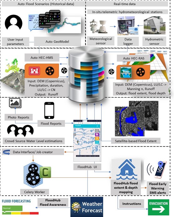
The FloodHub system is an integrated near-real-time flood monitoring and early warning system based on modelling, multi-source earth observation and crowdsourced data, which supports the decision makers in flood risk management. It runs operationally in the Mandra river basin, in Attica, Greece. This river basin was chosen because there was an extreme flash flood event in 2017, which affected both the urban and suburban area of Mandra with landslides, extensive million-euro damages to property and infrastructure, and 24 recorded fatalities, rendering it the deadliest flood in Greece in the last 40 years.
The FloodHub system is built around a fully scalable and transferable modular architecture that allows the near-real-time ingestion and assimilation of hydrometeorological parameters measured at three in-situ telemetric hydrometeorological stations (installed at 3 critical locations), satellite data (e.g. from high resolution Sentinels collected from the Hellenic Mirror Site), crowdsourced data (collected via the dedicated crowdsourcing platform), and simulations of a series of flood scenarios following hydrological and hydraulic modelling (using the open software HEC-HMS & HEC-RAS) in a multi-source data fusion concept.
The processed and modelled data are stored in a Data Cube into the PostGIS RDBMS, the latter offering a flexible environment for flood analysis and comparisons to facilitate the derivation of the most common hazard parameters namely the return period (T), the antecedent soil moisture conditions (CN), and the rainfall duration (d).
The innovation of the FloodHub system lies in the integration of different data sources so as to deliver a reliable operational awareness picture of the crisis every 5 minutes to all the relevant authorities, namely on 3 levels: Municipality, Region, Civil Protection General Secretariat. It offers increased reliability through a continuous validation and optimization of results, automation in assimilating flood modeling in real time, computational efficiency, openness, flexibility, scalability, transferability, and the speed to meet rapid awareness during the crisis.
In order to ensure the adequacy and reliability of the crowdsourcing data that are ingested in the FloodHub system, the FloodHub team organises workshops for the certified users, on how to use the web and mobile crowdsourcing platform. Trainings have been provided so far for the Operational Center of the Fire Service, the Municipality of Mandra, and the Associations of Civil Protection Volunteers. The response and the feedback received from the users and the decision-making authorities is very positive, and their interest is continuously increasing.
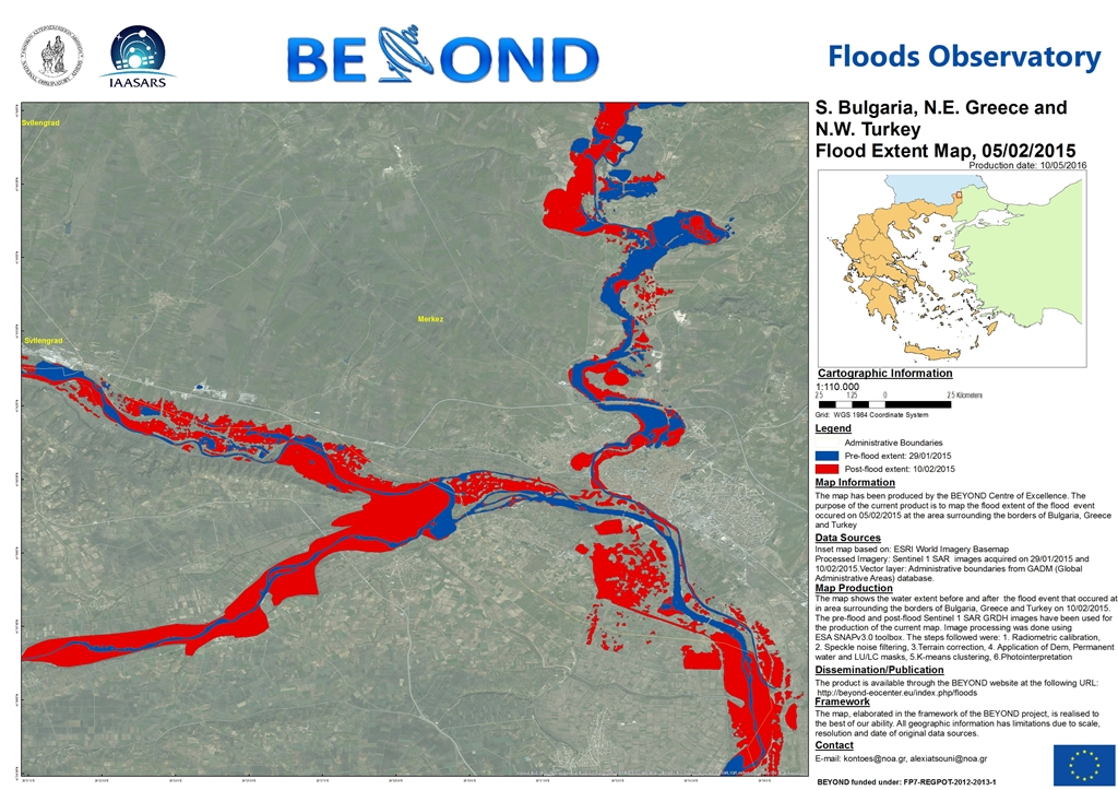
FLOODS OBSERVATORY:
a) It registers major flood events in Greece & South-Eastern Europe and publishes the flood mapping results, produced following the processing and photo-interpretation of satellite optical and radar images.
http://floodsobservatory.blogspot.gr/
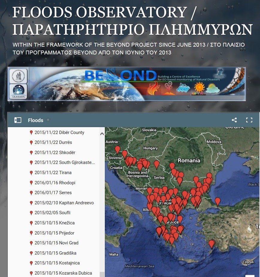
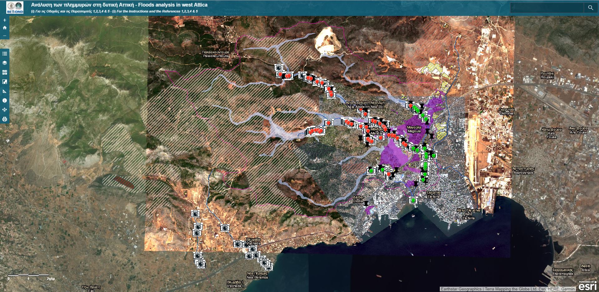
b) In selected cases, it proceeds to further analysis, conducting autopsies in the area for data collection and more detailed evaluation, including tracking the uncovered and covered parts of the watercourses but also their original natural flow, as well as the identification of critical points, the examination of the adequacy of the cross section of the watercourses and of the technical works, the shooting of photographs, and the formulation of relevant proposals on rehabilitation and prevention. As a result it produces a report and creates an interactive web application including detailed maps depicting the updated hydrological network after the possible human interventions, the mapping of the flood extent using satellite remote sensing, the simulation of the maximum flood extent using relevant modelling, as well as some of the critical factors, such as arbitrary human interventions within the beds of the watercourses, inadequacy of the existing technical works (either due to construction or due to non-cleaning / maintenance) or in some areas lack of flood protection and road drainage measures, and landscape changes due to burned areas upstream and urban expansions.
http://www.arcgis.com/apps/View/index.html?appid=35da5148b81a41eb84140314c854ad98
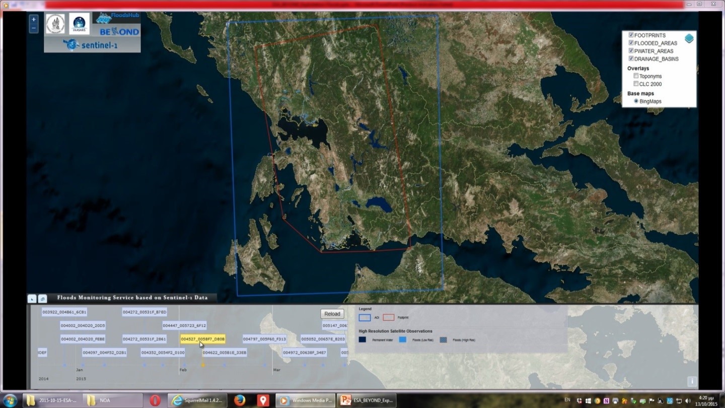
 FLOODS DIACHRONIC MAPPING:
It depicts the results of the diachronic mapping of flooded areas in selected river basins of special interest, following the processing of Sentinel images from the Hellenic National Sentinel Data Mirror Site, through a fully automated process.
http://195.251.203.238/floodhubweb/
CONTACT PERSON
Alexia Tsouni, This email address is being protected from spambots. You need JavaScript enabled to view it.