288172536 3123987727852438 8044874230096858150 n

Πυρκαγιά εξελίσσεται στη περιοχή Άγιος Ανδρέας στο Άγιο Όρος.Πυρκαγιά εξελίσσεται στη περιοχή Άγιος Ανδρέας στο Άγιο Όρος.Το γεγονός ανιχνεύθηκε από το FireHUB της Επιχειρησιακής μονάδας BEYOND του ΙΑΑΔΕΤ/ΕΑΑ στις 24 Ιουνίου 2022 στις 22:10. Παράλληλα στο σύστημα FFIS φαίνονται οι εστίες πυρκαγιάς σε χωρική ανάλυση 375m μέσω εικόνων VIIRS που λαμβάνουμε καθημερινά στις κεραίες μας.

287750532 3123165754601302 6370635612153010126 n

A large fire has been raging for 3 days in the Marmaris region of Turkey. In the following images we see the active fires, but also a first assessment of the burned area, as it emerged from the processing of medium resolution images received by the BEYOND EO Centre's Ground Station yesterday Thursday 23/06/2022.

 282615847 3107556139495597 4445367815387150030 n

Πυρκαγιά βρίσκεται σε εξέλιξη σε χαμηλή βλάστηση στην περιοχή Πουρνάρι του Δήμου Γλυφάδας. Το γεγονός ανιχνεύθηκε από το FireHUB της Επιχειρησιακής μονάδας BEYOND του ΙΑΑΔΕΤ/ΕΑΑ στις 13:40 τοπική ώρα.


 villia

Νέα εκτίμηση της καμένης έκτασης στην περιοχή των Βιλίων, ύστερα από επεξεργασία (χαρτογράφηση) δύο εικόνων υψηλής ανάλυσης Sentinel-2.


af vilia

Στο βίντεο βλέπουμε την εξέλιξη των ενεργών εστιών της πυρκαγιάς στα Βίλια Αττικής από την έναρξη στις 16/08/2021 εώς και σήμερα 19/08/2021. Οι ενεργές εστίες έχουν προκύψει από επεξεργασία δορυφορικών εικόνων VIIRS και MODIS. Στο πρώτο frame παρουσιάζεται η εικόνα Sentinel-2 με ημερομηνία λήψης 18/08/2021 και ώρα 09:05 UTC, όπου φαίνεται και το μεγάλο νέφος καπνού που έχει αναπτυχθεί. Το σύνολο των ενεργών εστιών που έχουν καταγραφεί στο διάστημα αυτό εμφανίζονται στο τελευταίο frame.


 villia 19august

H πυρκαγιά στα Βίλια βρίσκεται ακόμη σε εξέλιξη. Το γεγονός ξεκινησε στις 16 Αυγούστου 2021.
Ακολουθεί, μωσαϊκό 2 δορυφορικών εικόνων υψηλής ανάλυσης Sentinel- 2 με ημερομηνία λήψης 18/8/2021 και ώρα λήψης 12:05 τοπική. Η εκτίμηση βασίστηκε στην ψευδέγχρωμη σύνθεση. Η εκτιμώμενη έκταση είναι 6.995 εκτάρια (69.950 στρέμματα).


new olympia 12august

Νέα εκτίμηση της καμένης έκτασης στην ευρύτερη περιοχή της Ηλείας και Αρκαδίας. 12.480 εκτάρια εκτιμήθηκε η καμένη έκταση σύμφωνα με την επεξεργασία εικόνας υψηλής ανάλυσης Sentinel-2 (λήψη εικόνας 11/8, 12.20 τοπική).

evoia xrhseis ghs 11august

Xάρτης χρήσεων γης της Εύβοιας για την περιοχή που έχει πληγεί από την πυρκαγιά (Πηγη:Corine Land Cover 2018)
Οι εκτάσεις που έχουν καεί αφορούν:
Γεωργικές περιοχές - 9065 εκτ.
Τεχνητές ζώνες - 435 εκτ.
Εκτάσεις με αραιή βλάστηση - 80 εκτ.
Δασική βλάστηση - 19270 εκτ.
Χορτολιβαδικές εκτάσεις - 7772 εκτ.
Θαμνώδεις εκτάσεις - 9960 εκτ.


evoia 11august

46.582 εκτάρια η καμένη έκταση στην Εύβοια ύστερα από επεξεργασία (χαρτογράφηση) τεσσάρων εικόνων υψηλής ανάλυσης Sentinel-2 ( λήψη εικόνων11/8/2021, 12.20 τοπική ώρα.) ώστε να καλυφθεί όλη η περιοχή ενδιαφέροντος.

sentinelattiki

Η καμένη έκταση υπολογίζεται σε 6747 εκτάρια. Με τη λήψη επόμενης εικόνας θα επανέλθουμε με πιο λεπτομερή αποτίμηση.

H χαρτογράφηση της καμένης έκτασης έγινε με εικόνα υψηλής ανάλυσης Sentinel-2 η οποία λήφθηκε  8/8/2021 και 12.20 τοπική ώρα.


Copernicus EMS - Mapping provides all actors involved in the management of natural disasters, man-made emergency situations and humanitarian crises, with timely and accurate geospatial information derived from satellite remote sensing and completed by available in situ or open data sources. The information generated by the service can be used as supplied (e.g. as digital or printed map outputs). It may be further combined with other data sources (e.g. as digital feature sets in a geographic information system). In both cases it may support geospatial analysis and decision making processes of emergency managers. Copernicus EMS - Mapping is provided during all phases of the emergency management cycle, in two temporal modes, and free of charge for the users. It can be activated only by authorized users.

The infrastructure and excellence developed in the BEYOND Center of Excellence are actively involved in the provision of Risk & Recovery Mapping which consists of the on-demand provision of geospatial information in support of Emergency Management activities related to Emergency Support. This applies in particular to activities dealing with prevention, preparedness, disaster risk reduction and recovery phases. There are three broad product categories: Reference Maps, Pre-disaster Situation Maps and Post-disaster Situation Maps. The research developed in BEYOND, exploits satellite data and ingests fusions of geo-partial information and data in rush mode, when, where needed, for enhanced risk modelling and improved assessment of the expected disaster impacts.

The list of methodologies developed, adapted, validated, and used in BEYOND to address risk and recovery needs of the civil protection authorities worldwide are listed below (in more details in ANNEX III):

  • Seismic Methodologies: Seismic Hazard, Seismic Vulnerability, Seismic Vulnerability of Pipelines, Seismic Risk.
  • Lava Flow Methodologies: Lava Flow Hazard, Lava Flow Vulnerability, Lava Flow Risk.
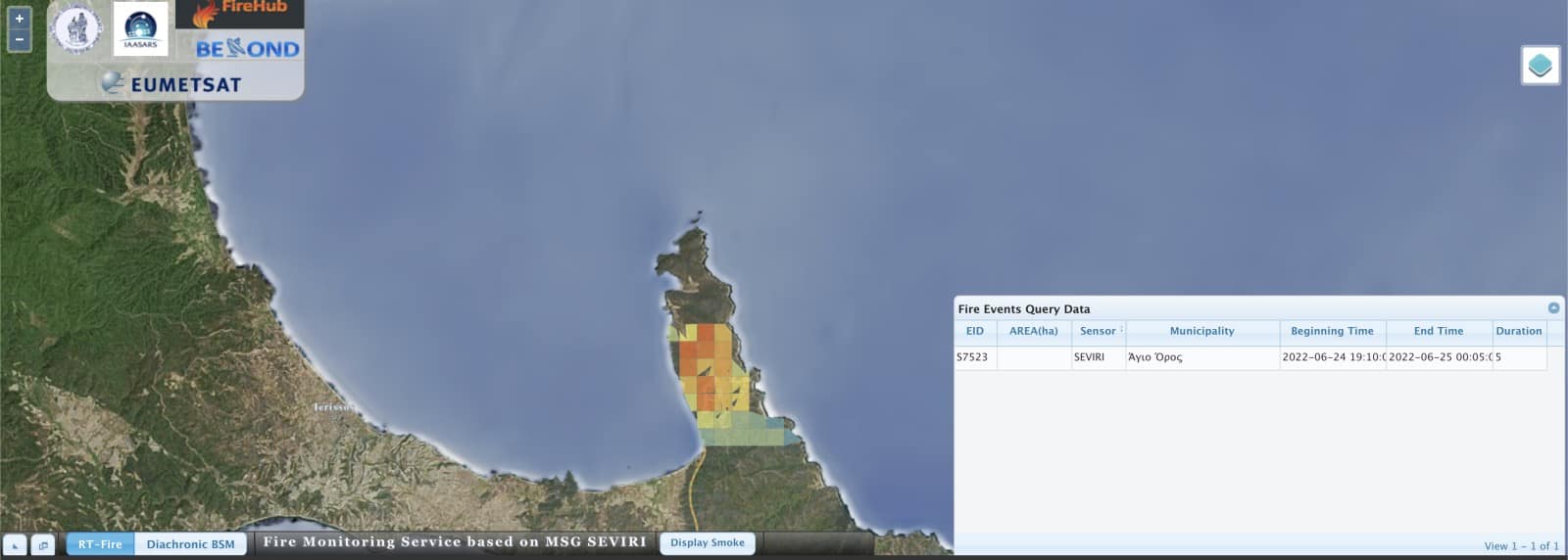
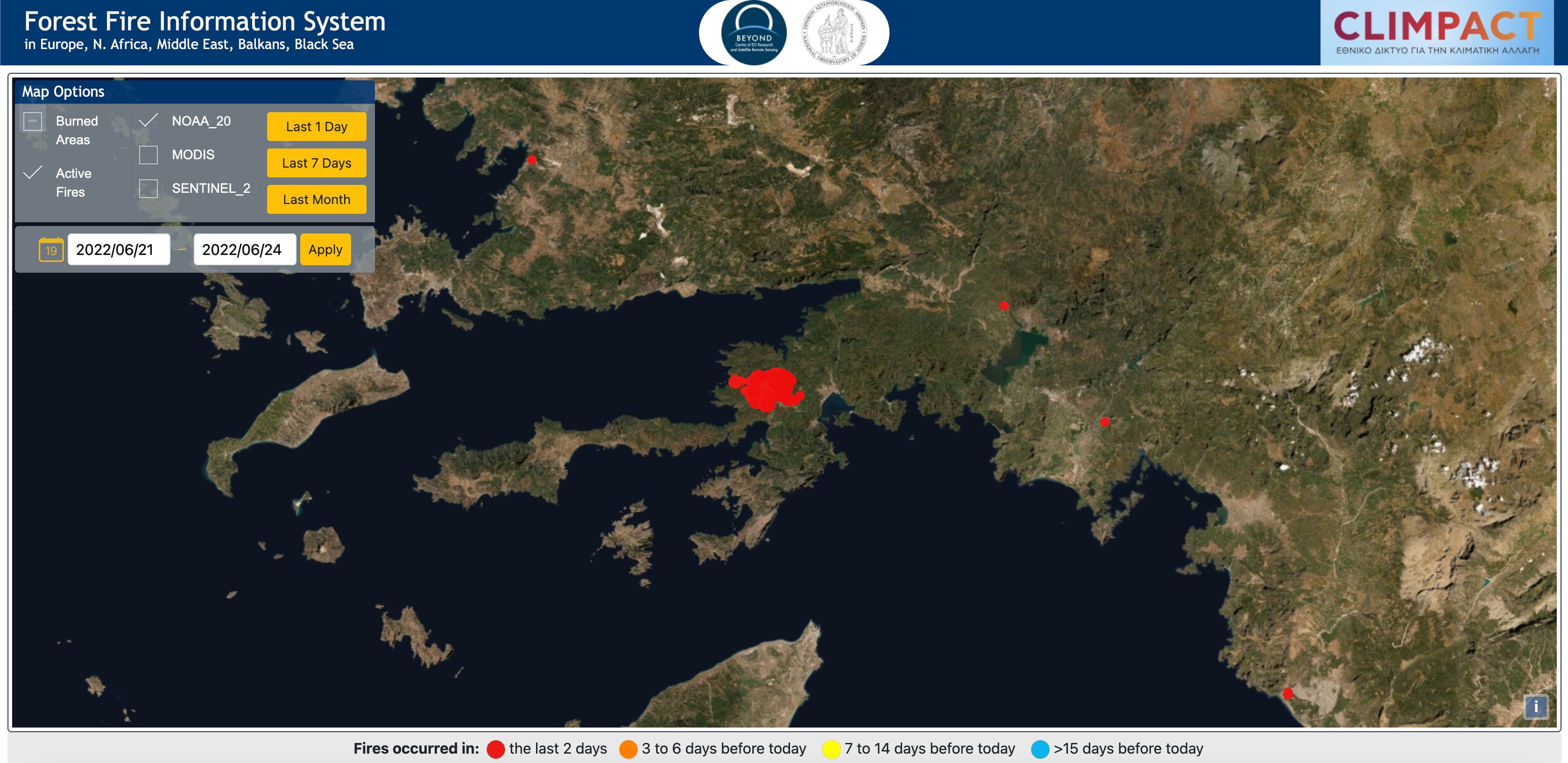
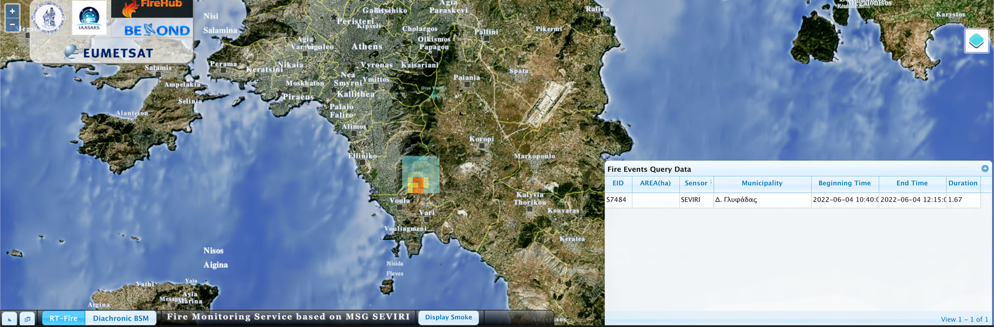
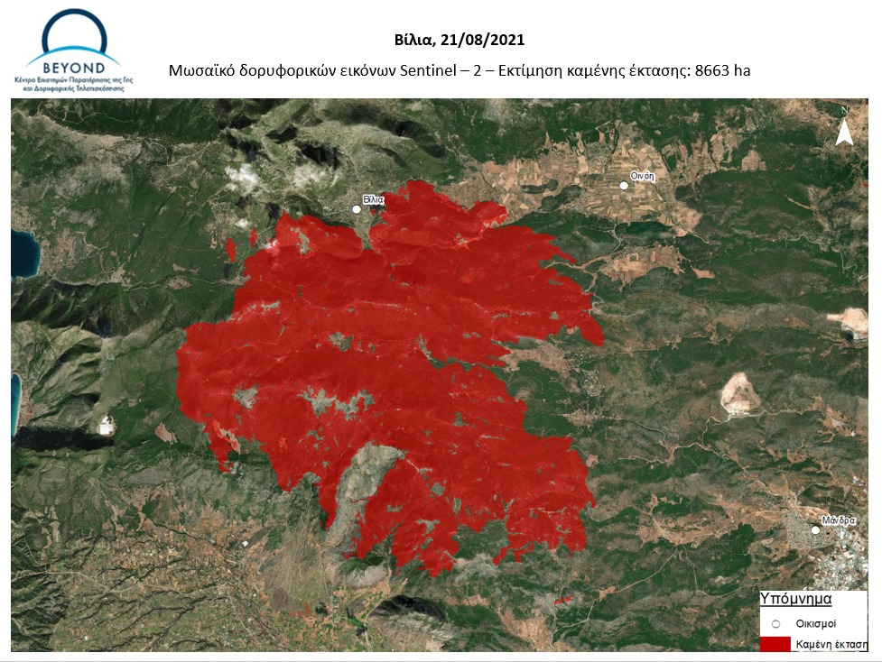
  • Forest Fires Methodologies: Fire Damage Delineation & Burn Severity Grading, Damage/Biomass Loss Statistics, Forest Fire Hazard, Population & Assets Vulnerability to Forest Fires, Forest Fire Risk – Population, Assets and Transportation Network at risk.
  • Industrial Accidents Methodologies: Industrial Accidents Hazard, Industrial Accidents Exposure, Industrial Accidents Risk.
  • Tsunami Methodologies: Tsunami Hazard Assessment, Assets Vulnerability to Tsunami, Storm Surge Hazard Risk.
  • Soil Erosion Methodology: Soil Erosion Hazard.
  • Coastal Erosion Methodology: Coastal Erosion Vulnerability.
  • Ground Deformation Methodology: Ground Deformation Dynamics.
  • Landslides Methodology: Landslide Hazard, Landslide Vulnerability, Landslide Risk.
  • Subsidence and Landslide Methodology: Subsidence and Landslide Risk.
  • Floods Methodology: Flood Delineation at peak conditions, Flood Depth at peak conditions, Flood Damage Assessment, Flood Hazard, Flood Vulnerability, Flood Risk, Flash Flood Hazard triggered by earthquakes, Flash Flood Risk triggered by earthquakes.
  • Disruption of Transportation Networks Methodology: Vulnerability of Disruption of Transportation Networks.

Up to now the BEYOND Center has been activated in the framework of the COPERNICUS EMERGENCY MANAGEMENT SERVICE in the following worldwide disaster risk and recovery cases :

An overview of missons in which UAVs were used to record raw data flighting above the affected from natural disasters areas; and to map and to assess the damages caused.