
On 15 November 2017, there was a flood after heavy rainfall in western Attica, mainly affecting the areas of Mandra and Nea Peramos. The tragic account is that 24 people have died, and a lot of infrastructure and assets have been destroyed completely or partially.
The team of the FloodHub service of BEYOND was activated immediately after the incident and analysed it, both by using satellite remote sensing and photo interpretation, and by autopsies in the area (21-23/11/2017), for data collection and more detailed evaluation, including tracking the uncovered and covered parts of the watercourses but also their original natural flow, as well as the identification of critical points (66), the examination of the adequacy of the cross section of the watercourses and of the technical works, the shooting of photographs (287), and the formulation of relevant proposals on rehabilitation and prevention.
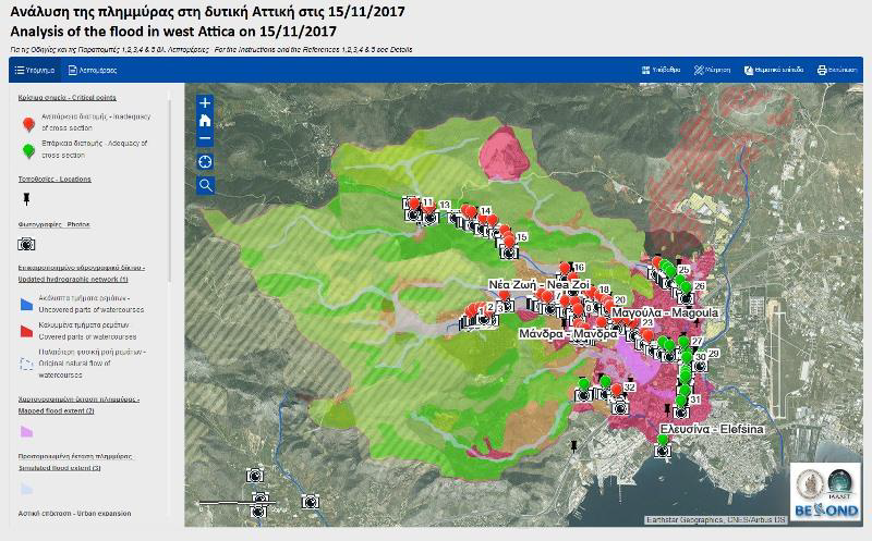
Among other things, FloodHub / BEYOND created an interactive web application and produced detailed maps depicting the updated hydrological network as it is today, after the human interventions (using information derived from the autopsies, the historical satellite images of Google Earth Pro 2002-2017, the historical aerophotos 1945-2007, the report of the Inspectors of Pubic Administration, and the HYDROSCOPE project), the mapping of the flood extent using satellite remote sensing (processing of WorldView-4 very high resolution image 0.31 m of 21/11/2017, photointerpretation, use of information derived from the autopsies, and additional information which was published), the simulation of the maximum flood extent by (using the HEC-RAS software (version 5.0.1, the EU-DEM of 25 m resolution, the analysis of the data of the meteorological radar XPOL of the Institute for Environmental Research and Sustainable Development of the National Observatory of Athens, the Corine Land Cover 2012, the urban expansion derived from the aerophotos and the Worldview-4 image, and the diachronically burnt areas derived from the BEYOND FireHub), as well as some of the critical factors which contributed to the immense destruction, such as arbitrary human interventions within the beds of the watercourses, inadequacy of the existing technical works (either due to construction or due to non-cleaning / maintenance) or in some areas lack of flood protection and road drainage measures, and partly landscape changes on the one hand due to some relatively small burned areas upstream, but mainly due to the urban expansions where it obstructs the flow of the watercourses.
The FloodHub/BEYOND has submitted a detailed report to all the relevant authorities in Greece, which is available in greek here: BEYOND-FLOODHUB-REPORT-MANDRA-2017.