Space Operations and Environmental Monitoring in Cyprus |Wednesday, July 15th 2020, 08:00 – 16.30 CEST
Space Operations and Environmental Monitoring in Cyprus |Wednesday, July 15th 2020, 08:00 – 16.30 CEST

ΠΡΟΣΚΛΗΣΗ ΕΚΔΗΛΩΣΗΣ ΕΝΔΙΑΦΕΡΟΝΤΟΣ για την Πλήρωση μίας (1) Θέσης Εξωτερικού Συνεργάτη(Κωδικός Θέσης: ΠΕDS4)στο Πλαίσιο του Έργου με Τίτλο«EUROGEOSS Showcases: Applications powered by Europe (E-SHAPE)» που χρηματοδοτείται από την Ευρωπαϊκή Επιτροπή.
A virtual workshop for "Early Warning for Epidemics" July 9th and 14th, 2020.
Interesting findings in our recent BEYOND publication!
Νεότερη εκτίμηση των καμένων εκτάσεων στην ευρύτερη περιοχή του Μαρτίνου (Δ. Λοκρών, Φθιώτιδα) από την πυρκαγιά της 19ης Ιουνίου 2020 - Latest estimation of the burned areas in the greater area of Martino (Mun. of Lokroi, Phthiotis) from the fire of June 19, 2020.
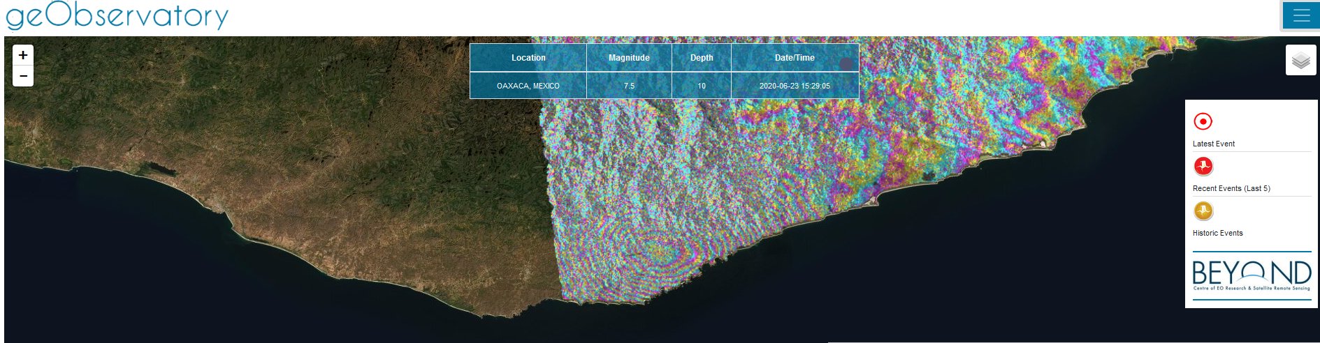
First co-seismic ascending interferogram for the 2020.06.23, M7.4 Santa María Zapotitlán, earthquake in Mexico. All interferograms that cover the event are available to download from BEYOND’s geObservatory service: http://geobservatory.beyond-eocenter.eu.
![]()
Initiation of 3 new, thematic working groups within GEO, June 2020
Three new, thematic working groups within GEO were formed and Greece is actively represented through highly esteemed members of its EO community.
BEYOND is organising a special session relevant to Multimodal Analysis and Retrieval of satellite images as part of the 27th International Conference on Multimedia Modeling, which will be held on January 25-27, 2021 in Prague, Czech Republic https://mmm2021.cz/.

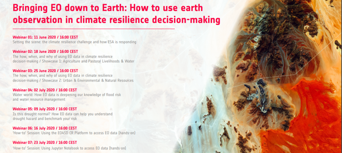
European Space Agency’s EO4SD climate cluster offers free webinar series on using Earth Observation to tackle climate change
BEYOND’s geObservatory was activated automatically, and produced a series of co-seismic and pre-seismic interferograms, which are available for viewing and downloading at http://geobservatory.beyond-eocenter.eu/.