![]() Click the FireHUB Button to visit the 24/7 Real-Time Fire Monitoring service
Click the FireHUB Button to visit the 24/7 Real-Time Fire Monitoring service
![]() Click the FireHUB Button to visit the Diachronic Burnt Scar Mapping
Click the FireHUB Button to visit the Diachronic Burnt Scar Mapping
![]() Click the FireHUB Button to visit the Forest Fire Information System in Europe, N. Africa, Middle East, Balkans, Black Sea
Click the FireHUB Button to visit the Forest Fire Information System in Europe, N. Africa, Middle East, Balkans, Black Sea
![]() Click the FireHUB Button to visit the Daily Fire Risk Map Prediction
Click the FireHUB Button to visit the Daily Fire Risk Map Prediction
![]() Click the FireHUB Button to visit the Smoke Dispersion Service
Click the FireHUB Button to visit the Smoke Dispersion Service
An Innovative and Prototype Early Warning and Fire Detection System in the Service of Operational Users and the Copernicus EMS.
MAIN OBJECTIVES & OUTCOMES
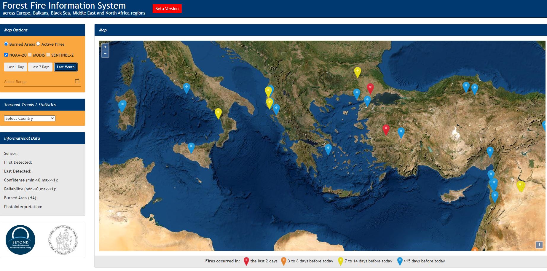
The main objectives of the FireHub of BEYOND is to facilitate the early warning and decision making in support to emergency response and evacuation processes, as well as to address diachronic and near real-time Burnt Scar Mapping needs, at various spatial resolutions. Both active-fire and BSM services are offered online and are publicly open, and cover the wider Mediterranean, the North Africa, the Balkans, the Middle East, and the Black Sea territories. The service is totally open to the public and user authorities for accessing the fire detection information in real time. FireHUB system is used by many operational users namely Fire Brigades Authorities, Copernicus EMS Risk and Recovery, Ministerial Services and Organizations for Forest Protection and Territorial Recovery and Planning, WWF, private sector entities, and national, Regional, and Local Authorities. From 2018 the FireHUB was integrated to the European Forest Fire Information System (EFFIS), and to the web system of the Global Fire Monitoring Center of the International Strategy of UN for Disaster Reduction (UNSDR). A new service known as Forest Fire Information System in Europe, N. Africa, Middle East, Balkans, Black Sea , provides daily near real information on active fires and burned areas, as well as statistics on the affected areas per time period and country over the large area covering Europe, North Africa, Middle East, Balkans, and Black Sea. The FIREHUB system uses a multitude of daily acquisitions of satellite images gathered by the antennas of the BEYOND Center, such as the X-/L-band antenna receiving EOS/AQUA, EOS/TERRA, SUOMI-NPP, JPSS NOAA-20 satellites, and the Hellenic Mirror Site that offers near real time acquisitions of S-1, S-2, and S-3.
SERVICES & PLATFORMS
The BEYOND FireHub System consists of two different services, namely the Real-Time Active Fire Monitoring service and the Real-Time and Diachronic Burnt Scar Mapping service.

Real-Time Fire Monitoring service is a 24/7 active fire detection service for effectively monitoring forest fires all over Greece in near-real time (Sifakis et al, 2011). It is continuously ingesting real time satellite acquisitions from every 5 minutes to a few hours from various missions namely the MSG SEVIRI (EUMETSAT), EOS/AQUA &TERRA, SUOMI NPP, and FY satellites. The system incorporates fully automatic processing chains for addressing early warning and dynamic monitoring challenges. It invokes innovative underlying processes for data fusion and modeling and runs prototype image processing and data classification algorithms to address the operational expectations set in the context of a longlasting co-designed and co-development service approach with the active participation of the end users. Enhanced processing allows improving the quality, reliability and spatial resolution for detecting active fires over the time. The system accounts for wind , ground morphology and altitudinal data, and integrates together with the satellite observations fuel and fire proneness data for deriving active fire predictions in the spatial resolution of 500 m, that is 50 times better compared to the raw resolution of the integested observations of the MSG SEVIRI sensor (3.5km). The web server is merging on-line the active fires with any available ancillary geo-spatial information including global datasets e.g. Google Earth, Corine CLC, Toponyms, OSM and POI data. The system is also offering the capability to retrieve and playback any fire events from the last ten years for re-analysis and study.
The Real-time service has been further enhanced during the last years with the systematic ingestion of middle resolution satellite data acquired by the BEYOND/NOA Ground Reception Stations. These are images from sensors as NPP/VIIRS, MODIS, NOAA/AVHRR, MetOP, and FengYun-3 that are acquired every 2-3 hours. The system and its derived services have been validated with real data, acquired over the years and has been calibrated so as to cover operational needs in the much wider area of Mediterranean, North Africa, Balkans, and the Middle East regions.

The Diachronic Burnt Scar Mapping service was initially developed as a fully automatic but off-line multi-sensor processing chain that takes as input satellite images of any available spatial and spectral resolution and produces precise diachronic burnt area and damage assessment products over the Greek territory. Actually based on the underlying BSM-NOA core processing, a multi-temporal analysis has been running for estimating and mapping the annual burnt areas and the corresponding damages for a period spanning the last 35 years. It has been based on using archived USGS Landsat TM, SPOT XS, IKONOS, FORMOSAT and recently Sentinel-2/3 imagery over the entire Greece. The Burnt Scar Mapping service is further enhanced so, depending on the acquired satellite imagery. Similar to the fire detection service, the BSM one is offered online and is publicly open, and covers the wider Mediterranean, the North Africa, the Balkans, and the Middle East territories. It is ingesting real time data acquired by the BEYOND/NOA Ground Segment and the Sentinel Collaborative Ground Segment, the so-called Hellenic National Sentinel Data Mirror Site, providing near real time access to Sentinel-2 and Sentinel-3 data. The underlying algorithm for automated Burnt Scar mapping is based on a custom implementation of the core BSM_NOA algorithm (Kontoes C.C. et al, 2009) combined with the Liu et al, 2014 methodology based on the use of Level Set Methods. Further modifications and optimizations were applied in order to produce accurate assessments and minimize the omission and commission error rates, as well as to adapt the proposed algorithms to the heterogeneous context of satellite systems used and their specificities in regard to data analysis.

BEYOND Center for Earth Observation Research and Satellite Remote Sensing operates the Forest Fire Information System. Our Center is responsible for providing a range of rapid satellite based active fire detection and burned area assessments products covering the entire region of Europe, Balkans, North Africa, the Black Sea and the Middle East around the clock: on a 24 hour basis, 7 days a week and 365 days a year.
The Center processes satellite data gathered by the acquisition station operate in BEYOND's facility at Penteli, as well as the Hellenic Mirror Site. Through the offered capability for processing in Real Time of SUOMI-NPP, NOAA-20, MODIS, and S-2 data, reliable and updated information on forest fires is provided on a daily basis, assisting the fire services and crisis management centers of EU and the neighboring regions. This information includes critical maps, data on the location and scale of individual fire outbreaks, as well as descriptions of the magnitude of the hazards. The service is also providing useful statistics on the affected areas in terms of Land Use/Land Cover types per fire event, country, year, etc.
The diachronically collected information as above is organised in well structured and dedicated data cubes for further exploitation and study of the fire behavior and proneness for fire ignition in the entire Mediterranean ecosystem.
The main advances in the state-of-the-art for the developed algorithms lie with the (a) innovative histogram matching for significantly improved classifications of burned/non burned areas over large geographical extents, (b) integration of diverse index capacities to better characterize the levels of burn severity and further extract the burnt scar product, (c) combined utilization of Level Set Methods (LSM) as one of the most state-of-the-art segmentation approaches, (d) sophisticated DB post-processing of the stored burned area products to uniquely identify the fire event (by assigning a unique id to the fire event) and generate the combined burned area extent by intersecting the different burned area observations over the days the disaster happens , (e) algorithmic adaptability to process any optical sensor provided it observes in the visible red, near-infrared and short-wave-infrared spectral wavelengths.
CONTACT PERSONS
Charalampos Kontoes, This email address is being protected from spambots. You need JavaScript enabled to view it. , Themistocles Herekakis, This email address is being protected from spambots. You need JavaScript enabled to view it., Ioannis Papoutsis, This email address is being protected from spambots. You need JavaScript enabled to view it., Dimitrios Vallianatos, This email address is being protected from spambots. You need JavaScript enabled to view it.

