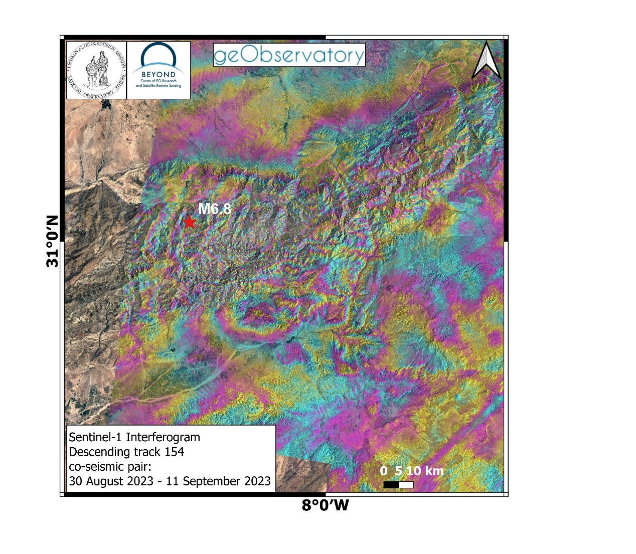
Δορυφορική συμβολομετρική απεικόνιση του πεδίου εδαφικής παραμόρφωσης από τον σεισμό στο Μαρόκο (8 Σεπτεμβρίου 2023).
Ισχυρός σεισμός πραγματοποιήθηκε στο Μαρόκο στις 8 Σεπτεμβρίου 2023, Μ6.8 (Sept. 8, 2023, 22:11:02 UTC). Υλικές καταστροφές και σοβαρές ανθρώπινες απώλειες προκλήθηκαν από τον σεισμό στο Μαρόκο. Η σεισμική δόνηση έγινε αισθητή στην οροσειρά του Υψηλού Άτλαντα στο Μαρόκο. Η οροσειρά αποτελεί τμήμα του Αλπικού ορογενετικού συστήματος και συνδέεται με ένα πολύπλοκο τεκτονικό καθεστώς, όπου παρατηρούνται επιφανειακά επωθητικά ρήγματα με κύρια διεύθυνση ΒΑ-ΝΔ. Η υπηρεσία geObservatory της επιχειρησιακής μονάδας BEYOND του ΙΑΑΔΕΤ/ΕΑΑ, αμέσως ενεργοποιήθηκε και κατέγραψε την εδαφική παραμόρφωση. Το πρώτο συμβολογράφημα δημιουργήθηκε με ζεύγος εικόνων Sentinel-1, καθοδικής τροχιάς δορυφόρου από τις 30 Αυγούστου 2023 και τις 11 Σεπτεμβρίου 2023. Στο συμβολογράφημα, που δημιουργήθηκε με αυτοματοποιημένο τρόπο από την πλατφόρμα geObservatory, παρουσιάζεται η εδαφική παραμόρφωση που προκλήθηκε από τον σεισμό. Κάθε κροσσός συμβολής, που παρουσιάζεται στο συμβολογράφημα, αντιστοιχεί σε εδαφική παραμόρφωση ίση με 2.8 εκ. Όλα τα διαφορικά συμβολογράμματα που σχετίζονται με τον σεισμό, θα είναι διαθέσιμα στην ιστοσελίδα του geΟbsevatory (http://geobservatory.beyond-eocenter.eu/), η οποία θα επικαιροποιείται, μόλις γίνονται διαθέσιμες νέες εικόνες Sentinel-1.
Co-seismic interferogram of Morocco earthquake (September 8, 2023)
A major seismic event occurred in Morocco in September 8, 2023, M6.8 (Sept. 8, 2023, 22:11:02 UTC). Severe damages and casualties, were induced by the earthquake in Morocco. The earthquake is located on the High Atlas mountain range in Morocco. The mountain range is part of the Alpine orogenic system, associated with transpressional tectonics and a as a result a complex fault system, where thrust faults with a predominant NE-SW direction are observed. The geObservatory service of the Operational Unit Center for Earth Observation Research and Satellite Remote Sensing BEYOND of the Institute of Astronomy and Astrophysics, Space Applications and Remote Sensing of the National Observatory of Athens, was activated by the earthquake and mapped co-seismic deformation. The first co-seismic interferogram was produced with Sentinel-1 SAR images of descending track 154, from August 30, 2023 and September 11, 2023. In the automatically produced co-seismic interferogram, fringes present the surface deformation in the line of sight direction, induced by the earthquake. Each fringe, corresponds to a ground deformation equal to 2.8 cm. All co-seismic and pre-seismic interferograms, associated with the event will be freely available in the geObsevatory website (http://geobservatory.beyond-eocenter.eu/), which will be continuously updated, as soon as new Sentinel-1 images become available.