CEMS Activations: Wildfire delineation and grading in Hungary
We are announcing that the dedicated efforts of BEYOND/NOA team and its partners (NTUA and IDCOM) under the supervision of JRC CEMS Risk and Recovery team have led to the delivery of reliable and comprehensive fire damage delineation and grading towards the recovery and restoration planning of the affected area at the northern part of the town Celldömölk, Vas County, Hungary in the support of the Central Duty Service of the National Directorate General for Disaster Management (HU).
What happened?
A vegetation fire broke out at the Northern part of the Celldömölk district, in Vas County, Hungary on September 5, 2024, and it was completely extinguished on September 9 by rain, causing significant damage and severe consequences to the local ecosystem as protected natural areas were affected.
After the official request of the Central Duty Service of the National Directorate General for Disaster Management (HU), our consortium was awarded by the Copernicus Emergency Management Service (CEMS) - Risk and Recovery Mapping (RRM) and delivered in time detailed maps and statistics regarding the level of the damage, as input in the decision making process for restoration actions inside the affected burned areas.
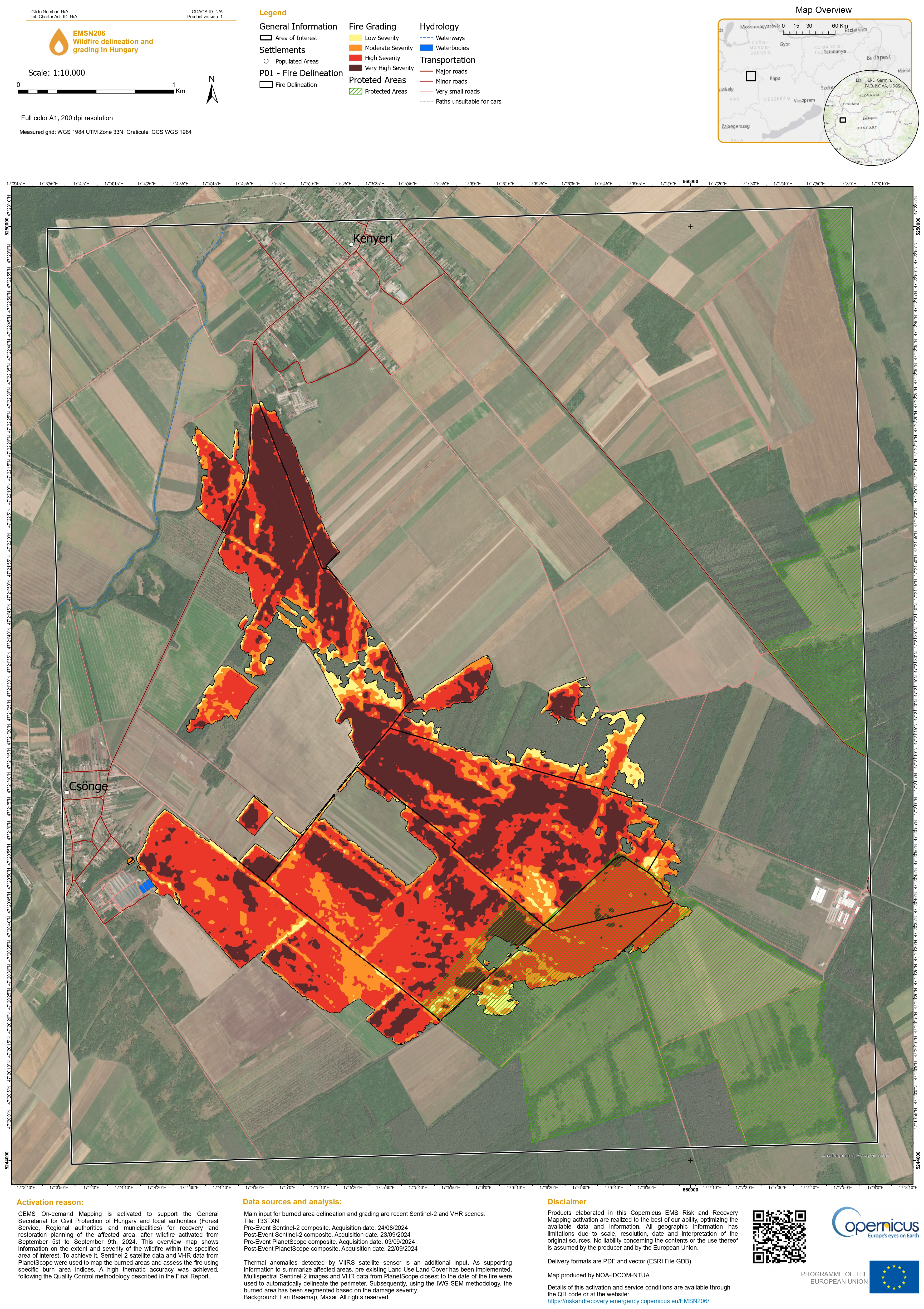
According to the study, the area being damaged is as wide as 535,7 ha corresponding to 272.7 ha high/very high severity burned, 232.9 ha medium severity burned and 30.1 ha low severity burned areas. The damages in regard to the natural landscape refer to approx. 53.1% tree cover followed by 43.2% grassland and 3.7% cropland.
Read more about our efforts here:
https://riskandrecovery.emergency.copernicus.eu/EMSN206/
- Map 1 below depicts the extent of the wildfire at Celldömölk, Vas County, Hungary and the damage grade of the burned area
- The short video depicts the affected area before and after the fire in Celldömölk district, in Vas County, Hungary.Celldömölk district, in Vas County, Hungary.
................................................................................................................................................................................................................
Θα θέλαμε να ανακοινώσουμε ότι οι προσπάθειες της ερευνητικής ομάδας της Επιχειρησιακής Μονάδας BEYOND του ΙΑΑΔΕΤ/ΕΑΑ και των συνεργατών της (Εθνικό Μετσόβιο Πολυτεχνείο και IDCOM) υπό την επίβλεψη της ομάδας «Risk and Recovery Mapping (#RRM)» της Υπηρεσίας Διαχείρισης Εκτάκτων Αναγκών του Copernicus (#CEMS) του Joint Research Centre (JRC) είχαν σαν αποτέλεσμα την επιτυχή παράδοση του έργου για την οριοθέτηση και τη διαβάθμιση των ζημιών της πληγείσας περιοχής Celldömölk στην Ουγγαρία, υποστηρίζοντας αποτελεσματικά τις προσπάθειες αποκατάστασης της περιοχής από την Central Duty Service of the National Directorate General for Disaster Management της Ουγγαρίας.
Το περιστατικό
Στις 5 Σεπτεμβρίου 2024, στο βόρειο τμήμα της περιοχής του Celldömölk, στην Ουγγαρία, εκδηλώθηκε φωτιά, η οποία κατασβέστηκε πλήρως από βροχή στις 9 Σεπτεμβρίου , προκαλώντας σοβαρές ζημιές και επιπτώσεις στο τοπικό οικοσύστημα, στο οποίο συμπεριλαμβάνονται προστατευόμενες φυσικές περιοχές.
Μετά από επίσημο αίτημα της Central Duty Service of the National Directorate General for Disaster Management της Ουγγαρίας προς την Υπηρεσία Διαχείρισης Εκτάκτων Αναγκών του Copernicus (#CEMS) - Risk and Recovery Mapping (#RRM), απονεμήθηκε στην κοινοπραξία το έργο της οριοθέτησης και διαβάθμισης των ζημιών της πληγείσας περιοχής. Η κοινοπραξία παρέδωσε λεπτομερείς χάρτες και στατιστικά στοιχεία σχετικά με το επίπεδο των ζημιών, προκειμένου να συμβάλει στην διαδικασία λήψης αποφάσεων για τη χάραξη δράσεων αποκατάστασης των πληγεισών καμένων περιοχών.
Σύμφωνα με τη μελέτη, η έκταση που έχει υποστεί ζημιές φτάνει συνολικά τα 535,7 εκτάρια, τα οποία αντιστοιχούν σε 272,7 εκτάρια υψηλής/πολύ υψηλής σοβαρότητας, 232,9 εκτάρια μέτριας σοβαρότητας και 30,1 εκτάρια χαμηλής σοβαρότητας καμένης περιοχής. Οι ζημιές σε σχέση με το φυσικό τοπίο αφορούν περίπου 53,1% δενδροκάλυψη, ακολουθούμενες από 43,2% χορτολιβαδικές εκτάσεις και 3,7% καλλιεργήσιμες εκτάσεις.
Περισσότερα για τις προσπάθειές μας μπορείτε να διαβάσετε εδώ: https://riskandrecovery.emergency.copernicus.eu/EMSN206/
Ο χάρτης 1 παρακάτω απεικονίζει την έκταση της πυρκαγιάς στο Celldömölk και τη διαβάθμιση της ζημιάς στην καμένη περιοχή
Το βίντεο απεικονίζει την περιοχή του Celldömölk πριν και μετά την πυρκαγιά.

Map 1 depicts the extent of the wildfire at Celldömölk, Vas County, Hungary and the damage grade of the burned area
Ο χάρτης 1 απεικονίζει την έκταση της πυρκαγιάς στο Celldömölk και τη διαβάθμιση της ζημιάς στην καμένη περιοχή
