
![]() Click the GeoHUB Button to visit the GeObservatory
Click the GeoHUB Button to visit the GeObservatory
Overview
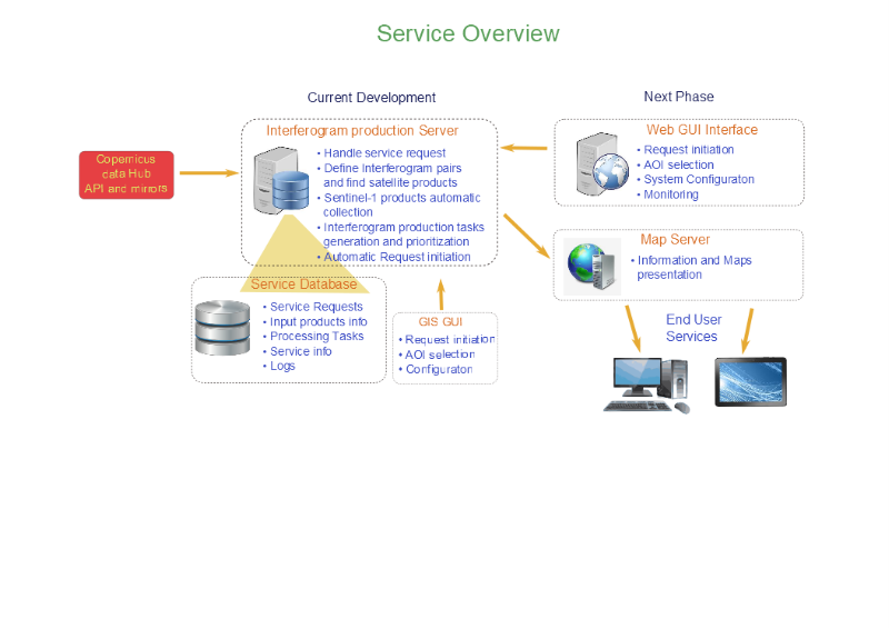
GeoHub is a fully automatic application that is activated to exploit Sentinel-1A and Sentinel-1B SAR image pairs, appropriately acquired in TOPS Interferometric Wide Swath mode before and after an earthquake, a volcanic eruption or a major landslide event, and creates differential interferograms (DInSAR) to map ground displacement. The SAR data are retrieved in real-time from the Hellenic National Sentinel Data Mirror Site, an ESA Collaborative Ground Segment operated by NOA and powered by a dedicated high bandwidth GEANT communication link operated by GRNET.
 |
 |
Main objectives & outcomes
The main objective of GeoHub of BEYOND is to deliver timely information to authorities, making a rapid assessment of the impact of abrupt geohazards on the assets on the ground. The powerful BEYOND/NOA servers, within minutes after receiving the appropriate Sentinel-1 satellite imagery, process these data using radar differential interferometry techniques, and promptly delivers to stakeholders constantly updated information on the evolution of the ground deformation in the hazard area. This information is extremely useful for both the international scientific community and the local authorities responsible for decision making for evacuation, emergency response, relief and reconstruction planning, and taking measures to protect peoples’ lives and their property.