 |
FRAMEWORK SERVICE CONTRACT FOR COPERNICUS EMERGENCY Program Call for tender JRC/IPR/2014/G.2/0012/OC 2015-2018 1.000.000 EUR |
Work that uses the infrastructure and the BEYOND Center of Excellence
Copernicus EMS - Mapping provides all actors involved in the management of natural disasters, man-made emergency situations and humanitarian crises, with timely and accurate geospatial information derived from satellite remote sensing and completed by available in situ or open data sources. The information generated by the service can be used as supplied (e.g. as digital or printed map outputs). It may be further combined with other data sources (e.g. as digital feature sets in a geographic information system). In both cases it may support geospatial analysis and decision making processes of emergency managers. Copernicus EMS - Mapping is provided during all phases of the emergency management cycle, in two temporal modes, and free of charge for the users. It can be activated only by authorized users.
The infrastructure and excellence developed in the BEYOND Center of Excellence are actively involved in the provision of Risk & Recovery Mapping which consists of the on-demand provision of geospatial information in support of Emergency Management activities related to Emergency Support. This applies in particular to activities dealing with prevention, preparedness, disaster risk reduction and recovery phases. There are three broad product categories: Reference Maps, Pre-disaster Situation Maps and Post-disaster Situation Maps. The research developed in BEYOND, exploits satellite data and ingests fusions of geo-partial information and data in rush mode, when, where needed, for enhanced risk modelling and improved assessment of the expected disaster impacts.
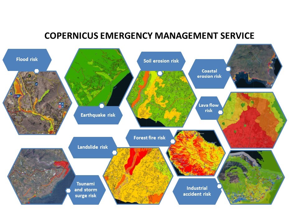
The list of methodologies developed, adapted, validated, and used in BEYOND to address risk and recovery needs of the civil protection authorities worldwide are listed below (in more details in ANNEX III):
- Seismic Methodologies: Seismic Hazard, Seismic Vulnerability, Seismic Vulnerability of Pipelines, Seismic Risk.
- Lava Flow Methodologies: Lava Flow Hazard, Lava Flow Vulnerability, Lava Flow Risk.
- Forest Fires Methodologies: Fire Damage Delineation & Burn Severity Grading, Damage/Biomass Loss Statistics, Forest Fire Hazard, Population & Assets Vulnerability to Forest Fires, Forest Fire Risk – Population, Assets and Transportation Network at risk.
- Industrial Accidents Methodologies: Industrial Accidents Hazard, Industrial Accidents Exposure, Industrial Accidents Risk.
- Tsunami Methodologies: Tsunami Hazard Assessment, Assets Vulnerability to Tsunami, Storm Surge Hazard Risk.
- Soil Erosion Methodology: Soil Erosion Hazard.
- Coastal Erosion Methodology: Coastal Erosion Vulnerability.
- Ground Deformation Methodology: Ground Deformation Dynamics.
- Landslides Methodology: Landslide Hazard, Landslide Vulnerability, Landslide Risk.
- Subsidence and Landslide Methodology: Subsidence and Landslide Risk.
- Floods Methodology: Flood Delineation at peak conditions, Flood Depth at peak conditions, Flood Damage Assessment, Flood Hazard, Flood Vulnerability, Flood Risk, Flash Flood Hazard triggered by earthquakes, Flash Flood Risk triggered by earthquakes.
- Disruption of Transportation Networks Methodology: Vulnerability of Disruption of Transportation Networks.
Up to now the BEYOND Center has been activated in the framework of the COPERNICUS EMERGENCY MANAGEMENT SERVICE in the following worldwide disaster risk and recovery cases (http://beyond-eocenter.eu/index.php/ems):
|
Activation code and web link |
Activation scope |
Country / Territory |
|
Multiple natural hazard risk assessment - Planning and Recovery |
Azores islands, Portugal |
|
|
Multiple natural hazard risk assessment - Planning and Recovery |
Madeira and Porto Santo islands, Portugal |
|
|
Earthquake risk assessment - Planning and Recovery |
Austria |
|
|
Post-disaster analysis, damage assessment, recovery and rehabilitation planning and monitoring, flood risk assessment, disaster preparedness and response mechanisms |
Bulgaria |
|
|
Forest fire damage assessment - Planning and Recovery |
Greece |
|
|
Post-disaster assessment of toxic cloud dispersion after an industrial accident |
Catalonia, Spain |
|
|
Ground deformation mapping and monitoring by satellite based multi-temporal DInSAR technique |
Ukraine |
|
|
Forest fire damage assessment and landslide risk |
Madeira island, Portugal |
|
|
Multiple natural hazards risk assessment for UNESCO |
Arica-Chile, Tacna-Peru, Maputo-Mozambique |
|
|
Forest fire risks assessment |
Croatia |
|
|
Detailed flood delineation |
Hildesheim, Germany |
|
|
Volcanic risk |
Democratic Republic of the Congo |
|
|
Flood assessment risk |
Sardinia, Italy |
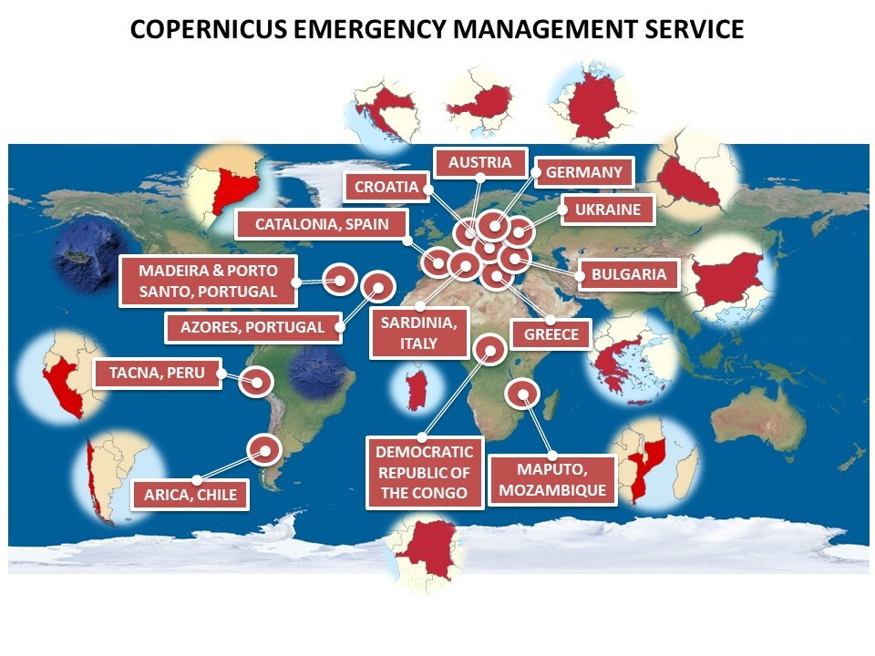
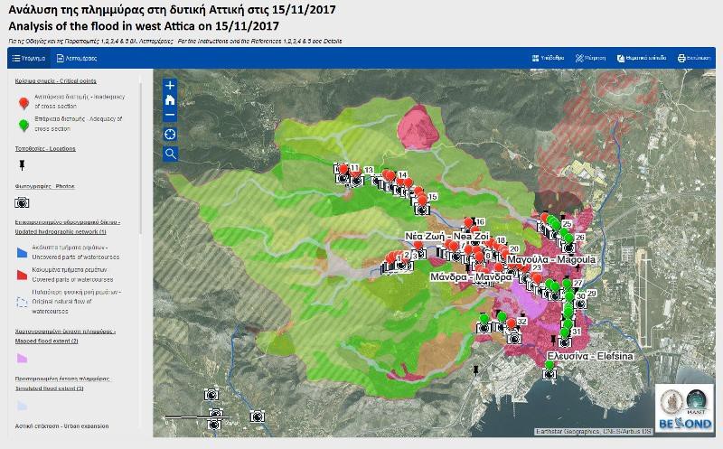
Furthermore, the BEYOND Center has been activated after the fatal flood in western Attica, Greece, on 15 November 2017, following a heavy rainfall, mainly affecting the areas of Mandra and Nea Peramos (24 casualties, and a lot of infrastructure and assets destroyed completely or partially). It produced flood delineation and proposed mitigation measures (http://beyond-eocenter.eu/index.php/floods/mandra2017).