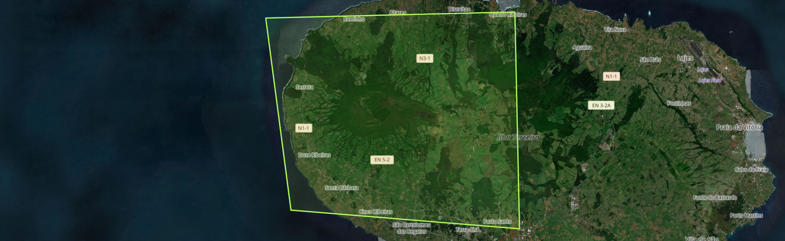
Copernicus Emergency Management Service (CEMS) Activations: Ground motion monitoring in Terceira Island, Azores
We announce that the successful collaboration between our team-NOA/BEYOND, NTUA, and IDCOM, under the supervision of JRC Copernicus EMS Risk and Recovery Mapping (RRM), has resulted in valuable scientific insights on ground displacements monitoring in Santa Barbara volcano, on Terceira Island.
By leveraging Sentinel-1 images and advanced InSAR techniques, following the analysis provided by the EGMS service until December 2023, a time-series analysis was performed to monitor deformation in Santa Barbara volcano over time. Following the seismic activity initiated on June 2022 and January 2024, the analysis presented surface deformation trends and patterns on Terceira Island. Finally, the geological interpretation of the observed InSAR deformation, provided critical information about the deformation trends on the island and contributed in planning of risk reduction activities.
What happened?
Since June 2022, a seismic crisis in Terceira Island, was initiated. On January 14, 2024 an M4.5 earthquake occurred, with an approximate epicenter 1 km E of Serreta. Increasing seismic activity in the Island since 2022, lead the Institute of Volcanology of the University of the Azores (IVAR) to increase the volcanic alert level of Santa Barbara volcano on Terceira Island to level 3. Low- intensity shallow earthquakes recorded in the island. Although, no outgassing or deformation are observed, the University of the Azores, indicated that the alert level, could rise. Therefore, the objective of the current activation is to employ SAR Interferometry, to asses ground displacements in Terceira Island and provide to the SRPCBA, valuable insights on the deformation trends in the AOI, following the years after the Copernicus EGMS analysis.
What was achieved?
- Following, the seismic activity on the island, Sentinel-1 images from June 2022, January 2024 and June 2024, were analyzed.
- Interferograms and displacement maps were produced, with dates before, during and after the intense seismic activity initiated on June 2022 and January 2024.
- Vertical and horizontal displacements from May 2017 up to September 2024, using Sentinel-1 images in Terceira Island, were estimated.
- Time-series plots of vertical and horizontal displacements, were generated and trend analysis was performed.
What was produced?
For the InSAR analysis on Terceira island, we produced:
- Final Technical Report detailing all the work carried out by NOA, NTUA & IDCOM.
- 1 Geodatabase which contains all the data produced for the project
- 4 On-line deliverables (Storymap, Dashboard, Webscene and Webmap) that interactively present all the activation results.
The results enriched the existing knowledge on the deformation trends in Terceira Island and contributed in the planning of risk reduction activities, including evacuation plans and the protection of sensitive areas.
Read more about this huge amount of work here:
See the video here about the Ground motion monitoring in Terceira Island, Azores
..........................................................................................................................................................................................................................
Copernicus Emergency Management Service (CEMS) Activations: Ground motion monitoring in Terceira Island, Azores
Ανακοινώνουμε ότι η επιτυχημένη συνεργασία μεταξύ της Επιχειρησιακής Μονάδας BEYOND του ΙΑΑΔΕΤ/ΕΑΑ, του Εθνικού Μετσόβιου Πολυτεχνείου και της IDCOM, υπό την επίβλεψη της ομάδας της Υπηρεσίας «Risk and Recovery Mapping (#RRM)» της Διαχείρισης Εκτάκτων Αναγκών του Copernicus (#CEMS) του Joint Research Centre (JRC), απέφερε πολύτιμες επιστημονικές γνώσεις για την παρακολούθηση των εδαφικών μετατοπίσεων στο ηφαίστειο Santa Barbara στη Νήσο Terceira .
Χρησιμοποιώντας εικόνες Sentinel-1 και προηγμένες τεχνικές διαφορικής συμβολομετρίας ραντάρ, πραγματοποιήθηκε ανάλυση χρονοσειρών για την παρακολούθηση εδαφικών παραμορφώσεων στο ηφαίστειο Santa Barbara. Μετά τη σεισμική δραστηριότητα που ξεκίνησε τον Ιούνιο του 2022 και τον Ιανουάριο του 2024, η ανάλυση παρουσίασε τάσεις εδαφικής παραμόρφωσης στη Νήσο Terceira. Τέλος, η γεωλογική ερμηνεία της εδαφικής παραμόρφωσης που προέκυψε από την διαφορική συμβολομετρία ραντάρ, παρείχε κρίσιμες πληροφορίες για τις τάσεις παραμόρφωσης στο νησί και συνέβαλε στον σχεδιασμό δραστηριοτήτων μείωσης του κινδύνου.
Τι συνέβη;
Από τον Ιούνιο του 2022, ξεκίνησε μια σεισμική κρίση στη Νήσο Terceira. Στις 14 Ιανουαρίου 2024, σημειώθηκε σεισμός μεγέθους 4,5 με εκτιμώμενο επίκεντρο περίπου 1 χλμ. ανατολικά της Σερέτα. Η αυξανόμενη σεισμική δραστηριότητα στο νησί από το 2022 οδήγησε το Ινστιτούτο Ηφαιστειολογίας του Πανεπιστημίου των Αζορών να αυξήσει το επίπεδο κινδύνου, λόγω του ηφαιστείου της Santa Barbara στη Νήσο Terceira, στο επίπεδο 3. Παρόλο που δεν παρατηρήθηκαν εκλύσεις αερίων ή εδαφικές παραμορφώσεις, το Πανεπιστήμιο των Αζορών τόνισε ότι το επίπεδο συναγερμού θα μπορούσε να αυξηθεί. Επομένως, ο στόχος της τρέχουσας ενεργοποίησης είναι η χρήση της διαφορικής συμβολομετρίας ραντάρ για τον προσδιορισμό των εδαφικών μετακινήσεων στη Νήσο Terceira και η παροχή πολύτιμων πληροφοριών για τις τάσεις παραμόρφωσης στην περιοχή ενδιαφέροντος στην Υπηρεσία Πολιτικής Προστασίας των Αζορών (Πορτογαλία), μετά την διαθέσιμη ανάλυση της υπηρεσίας EGMS του Copernicus.
Τι επιτεύχθηκε;
- Αναλύθηκαν εικόνες Sentinel-1 από τον Ιούνιο του 2022, τον Ιανουάριο του 2024 και τον Ιούνιο του 2024.
- Παρήχθησαν συμβολογραφήματα και χάρτες μετατοπίσεων με ημερομηνίες πριν, κατά τη διάρκεια και μετά την έντονη σεισμική δραστηριότητα που ξεκίνησε τον Ιούνιο του 2022 και τον Ιανουάριο του 2024.
- Υπολογίστηκαν κατακόρυφες και οριζόντιες μετατοπίσεις από τον Μάιο του 2017 έως τον Σεπτέμβριο του 2024, χρησιμοποιώντας εικόνες Sentinel-1 στη Νήσο Terceira.
- Δημιουργήθηκαν διαγράμματα χρονοσειρών για τις κατακόρυφες και οριζόντιες μετατοπίσεις και πραγματοποιήθηκε ανάλυση των τάσεων παραμόρφωσης.
Τι παρήχθη;
Για την ανάλυση InSAR στη Νήσο Terceira, δημιουργήθηκαν:
- Τεχνική Έκθεση που περιγράφει όλες τις εργασίες που πραγματοποιήθηκαν από το ΕΑΑ, το ΕΜΠ και την IDCOM.
- Μια γεωβάση δεδομένων που περιλαμβάνει όλα τα γεωχωρικά δεδομένα που παρήχθησαν για το έργο.
- 4 online παραδοτέα (Storymap, Dashboard, Webscene και Webmap) που παρουσιάζουν διαδραστικά όλα τα αποτελέσματα της ενεργοποίησης.
Τα αποτελέσματα εμπλούτισαν την υπάρχουσα γνώση για τις τάσεις παραμόρφωσης στη Νήσο Terceira, ενώ συνέβαλαν στον σχεδιασμό κατάλληλων δράσεων για τη μείωση του κινδύνου, συμπεριλαμβανομένων των σχεδίων εκκένωσης και της προστασίας των ευαίσθητων περιοχών.
Διαβάστε περισσότερα για το τεράστιο έργο μας εδώ:
Δείτε εδώ το σχετικό video