Δορυφορική συμβολομετρική απεικόνιση του πεδίου εδαφικής παραμόρφωσης από τον σεισμό στο Μαρόκο, 8 Σεπτεμβρίου 2023
Η υπηρεσία geObservatory της επιχειρησιακής μονάδας BEYOND του ΙΑΑΔΕΤ/ΕΑΑ, που ενεργοποιήθηκε και κατέγραψε την εδαφική παραμόρφωση, από τον σεισμό στο Μαρόκο, Μ6.8 (Sept. 8, 2023, 22:11:02 UTC) και παρήγαγε συμβολομετρικά προϊόντα πριν και μετά από το σεισμικό γεγονός. Ο χάρτης εδαφικής παραμόρφωσης, του πρώτου συμβολογραφήματος που δημιουργήθηκε με ζεύγος εικόνων Sentinel-1, καθοδικής τροχιάς δορυφόρου από τις 30 Αυγούστου 2023 και τις 11 Σεπτεμβρίου 2023, παρήχθη αυτόματα από την πλατφόρμα geObservatory. Στον χάρτη εδαφικής παραμόρφωσης, παρουσιάζονται οι μετατοπίσεις του εδάφους, στην ευρύτερη περιοχή γύρω από το επίκεντρο του σεισμού, με μέγιστες τιμές 10cm και -10cm ως προς τη διεύθυνση δορυφόρου-στόχου. Θετικές τιμές παραμόρφωσης αντιστοιχούν σε μείωση της απόστασης δορυφόρου-στόχου, ενώ αρνητικές τιμές, σε αύξηση της απόστασης δορυφόρου-στόχου. Όλα τα διαφορικά συμβολογράμματα που σχετίζονται με τον σεισμό, θα είναι διαθέσιμα στην ιστοσελίδα του geΟbsevatory (http://geobservatory.beyond-eocenter.eu/), η οποία θα επικαιροποιείται, μόλις γίνονται διαθέσιμες νέες εικόνες Sentinel-1.
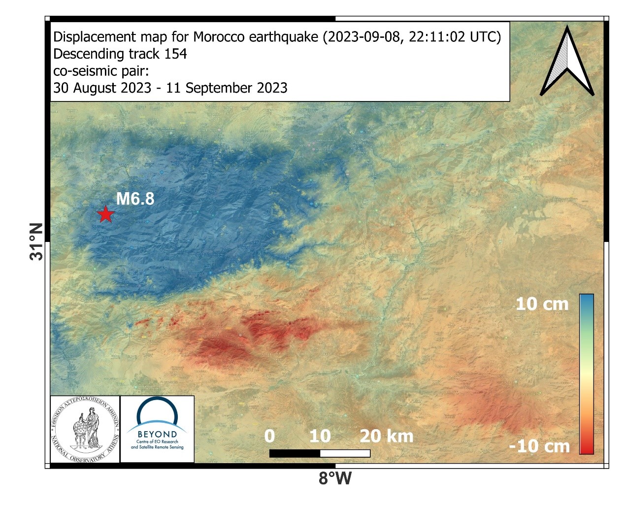
Displacement map of Morocco earthquake, September 8, 2023, 22:11:02 UTC
The geObservatory service of the Operational Unit Center for Earth Observation Research and Satellite Remote Sensing BEYOND of the Institute of Astronomy and Astrophysics, Space Applications and Remote Sensing of the National Observatory of Athens, was activated by the Morocco M6.8 (Sept. 8, 2023, 22:11:02 UTC) earthquake and produced a series of pre-seismic and co-seismic interferometric products, associated with the seismic event. The displacement map of the first co-seismic interferogram, produced with Sentinel-1 SAR images of descending track 154, from August 30, 2023 and September 11, 2023, was automatically produced by the geObservatory. In the displacement map, surface deformation in the broader area around the epicenter is presented, with maximum and minimum rates of 10cm and -10cm in the line-of-sight direction. Positive deformations correspond to a decrease in the sensor-target distance while negative values, to an increase of the sensor-target distance. All co-seismic and pre-seismic interferograms, associated with the event will be freely available in the geObsevatory website (http://geobservatory.beyond-eocenter.eu/), which will be continuously updated, as soon as new Sentinel-1 images become available.