GeoHub

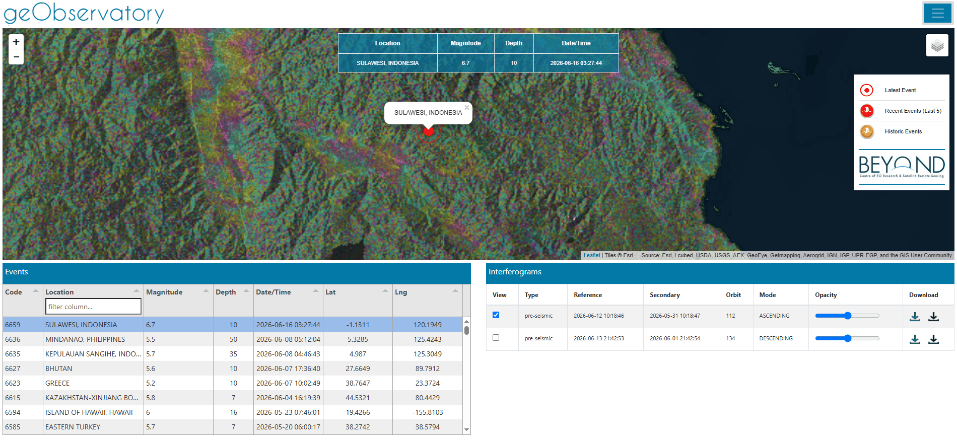
GeObservatory is activated in major geohazard events, such as earthquakes, volcanic activity etc. and automatically produces a series of co-event differential interferograms based on Sentinel-1 SAR data, to map the surface deformation associated with the event. The role of geObservatory is twofold: firstly, it provides to emergency management authorities with a rapid assessment of ground deformation, secondly it produces and maintains a global observatory of differential interferograms associated with catastrophic geo-events.
GeoHub is a fully automatic application that is activated to exploit Sentinel-1A and Sentinel-1B SAR image pairs, appropriately acquired in TOPS Interferometric Wide Swath mode before and after an earthquake, a volcanic eruption or a major landslide event, and creates differential interferograms (DInSAR) to map ground displacement. The SAR data are retrieved in real-time from the NOA-Harvester container application. The Harvester application collects satellite data from providers such as Copernicus Data Space Ecosystem (CDSE), CREODIAS and NASA Earthdata utilizing in the same time the NOA's Copernicus ground segment, a collaborative mirror site of the CDSE.

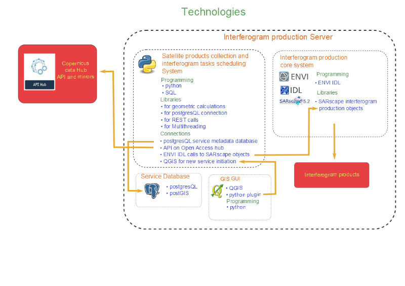
Sentinel-1 SLC images, covering the AOI are automatically processed invoking the processing chain developed in the Operational Unit BEYOND Center for Earth Observation Research and Satellite Remote Sensing of NOA, the so-called geObservatory. Sentinel-1 interferograms from both ascending and descending satellite passes, will be produced, following the seismic activity the event triggered. The optimal interferometric pairs will be selected based on the minimization of temporal and perpendicular baselines. Precise orbit data, provided by ESA and Shuttle Radar Topography Mission (SRTM) version 4 DEM with a resolution of one arc-second, are used to correct the topography effect.
| Event Location | Magnitude (Mw) | Depth (km) | Event DateTime |
|---|---|---|---|
| Ethiopia | 5.7 | 10 | 04/01/2025 00:52 |
| Western Xizang, China | 7.1 | 10 | 07/01/2025 01:05 |
| Southern Qinghai, China | 5.7 | 10 | 08/01/2025 07:44 |
| Taiwan | 6.0 | 10 | 20/01/2025 16:17 |
| Leyte, Philippines | 5.7 | 10 | 22/01/2025 23:39 |
| Tibet, China (Autonomous Region) | 7.1 | 10 | 07/01/2025 09:05 |
| Honduras, Swan Islands (offshore) | 7.6 | 10 | 08/02/2025 04:35 |
| Myanmar, Sagaing Region | 7.7 | 10 | 28/03/2025 12:50 |
| Tonga, Haapai (offshore) | 7.0 | 31 | 30/03/2025 14:20 |
| Western Turkey (Sea of Marmara) | 6.2 | 7 | 23/04/2025 09:49 |
| Magallanes, Chile (offshore) | 7.4 | 10 | 02/05/2025 16:25 |
| Alaska, USA (offshore) | 7.3 | 38 | 16/07/2025 06:30 |
| Kamchatka, Russia (offshore) | 7.4 | 34 | 20/07/2025 08:45 |
| Macquarie Island, Australia (offshore) | 7.0 | 31 | 28/07/2025 11:55 |
| Kamchatka, Russia (offshore) | 8.8 | 35 | 29/07/2025 17:25 |
| Drake Passage, Antarctica (offshore) | 7.5 | 10.8 | 22/08/2025 09:40 |
| Kunar, Afghanistan | 6.0 | 8 | 31/08/2025 15:30 |
| Kamchatka, Russia (offshore) | 7.8 | 19.5 | 18/09/2025 12:30 |
| Cebu, Philippines (Central Visayas offshore) | 6.9 | 10 | 30/09/2025 18:50 |
| Davao Oriental, Philippines (offshore) | 7.4 | 59.4 | 10/10/2025 14:30 |
| Drake Passage, Antarctica (offshore) | 7.6 | 10.5 | 10/10/2025 03:15 |
| Western Turkey (Sındırgı region) | 6.0 | 4 | 27/10/2025 19:48 |
| Balkh, Afghanistan | 6.2 | 28 | 02/11/2025 13:45 |
| Vanuatu | 7.2 | 25 | 15/11/2025 12:05 |
| Kuril Islands, Russia | 6.8 | 42 | 18/11/2025 07:20 |
| Papua New Guinea | 6.5 | 38 | 22/11/2025 10:15 |
| Bangladesh, Dhaka | 5.4 | 27 | 21/11/2025 08:30 |
| Aomori, Japan (offshore - Sanriku) | 7.6 | 45.5 | 08/12/2025 23:15 |
| Alaska, USA (onshore) | 7.0 | 5 | 06/12/2025 19:45 |