The main objectives of the FloodHub of BEYOND is to contribute, by using satellite remote sensing, to flood risk management focused on prevention, protection and preparedness, in order to reduce and manage the risks that floods pose to human health, the environment, cultural heritage, economic activity and infrastructure.
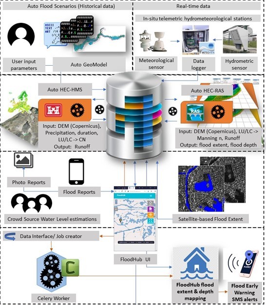
The FloodHub system is an integrated near-real-time flood monitoring and
early warning system based on modelling, multi-source earth observation and
crowdsourced data, which supports the decision makers in flood risk management.
It runs operationally in the Mandra river basin, in Attica, Greece. This river
basin was chosen because there was an extreme flash flood event in 2017, which
affected both the urban and suburban area of Mandra with landslides, extensive
million-euro damages to property and infrastructure, and 24 recorded fatalities,
rendering it the deadliest flood in Greece in the last 40 years.
The FloodHub system is built around a fully scalable and transferable modular
architecture that allows the near-real-time ingestion and assimilation of
hydrometeorological parameters measured at three in-situ telemetric
hydrometeorological stations (installed at 3 critical locations), satellite data
(e.g. from high resolution Sentinels collected from the Hellenic Mirror Site),
crowdsourced data (collected via the dedicated crowdsourcing platform), and
simulations of a series of flood scenarios following hydrological and hydraulic
modelling (using the open software HEC-HMS & HEC-RAS) in a multi-source data
fusion concept.
The processed and modelled data are stored in a Data Cube into the PostGIS
RDBMS, the latter offering a flexible environment for flood analysis and
comparisons to facilitate the derivation of the most common hazard parameters
namely the return period (T), the antecedent soil moisture conditions (CN), and
the rainfall duration (d).
The innovation of the FloodHub system lies in the integration of different data
sources so as to deliver a reliable operational awareness picture of the crisis
every 5 minutes to all the relevant authorities, namely on 3 levels:
Municipality, Region, Civil Protection General Secretariat. It offers increased
reliability through a continuous validation and optimization of results,
automation in assimilating flood modeling in real time, computational
efficiency, openness, flexibility, scalability, transferability, and the speed
to meet rapid awareness during the crisis.
In order to ensure the adequacy and reliability of the crowdsourcing data that
are ingested in the FloodHub system, the FloodHub team organises workshops for
the certified users, on how to use the web and mobile crowdsourcing platform.
Trainings have been provided so far for the Operational Center of the Fire
Service, the Municipality of Mandra, and the Associations of Civil Protection
Volunteers. The response and the feedback received from the users and the
decision-making authorities is very positive, and their interest is continuously
increasing.
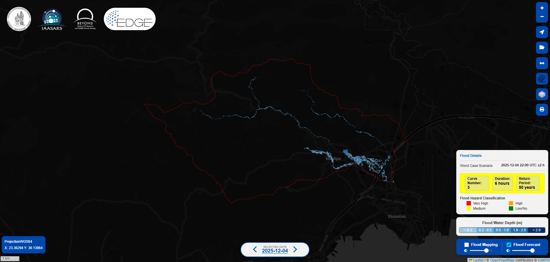
An operational service providing flood predictions (namely flood extent and depth information) up to two days in advance through the integration of high-resolution weather forecasts. It also provides advance warnings for upcoming flood events, particularly flash floods. This enhanced capability supports civil protection authorities in proactive decision-making, including timely alert issuance, public safety instructions, evacuation planning, traffic management, and emergency response. In addition, the use case contributes to the implementation of key international and European policy frameworks, including the EU Floods Directive (2007/60/EC), the Sendai Framework for Disaster Risk Reduction, the UN Sustainable Development Goals, and the UN Early Warnings for All initiative.
The datasets used in the system consist of both static and dynamic data sources. Static datasets include a Digital Elevation Model (DEM) provided by the National Cadastre and Mapping Agency S.A. of Greece, Curve Number data, Ombrian curves and hydrography data from the Ministry of Environment & Energy, Land Use/Land Cover data from the Copernicus Land Service and burnt scar mapping from FireHub/NOA, Infrastructure-related information, including building footprints and road networks, was obtained from OpenStreetMap. Dynamic datasets comprise real-time observations from three telemetric hydrometeorological stations, including water stage and precipitation time series provided by NOA, as well as forecast precipitation outputs from the WRF-ARW numerical weather prediction model. The combined use of static and dynamic datasets allows the system to account for both fixed spatial characteristics and time-varying hydrometeorological conditions that influence flood risk.
https://floodhub.beyond-eocenter.eu/forecast/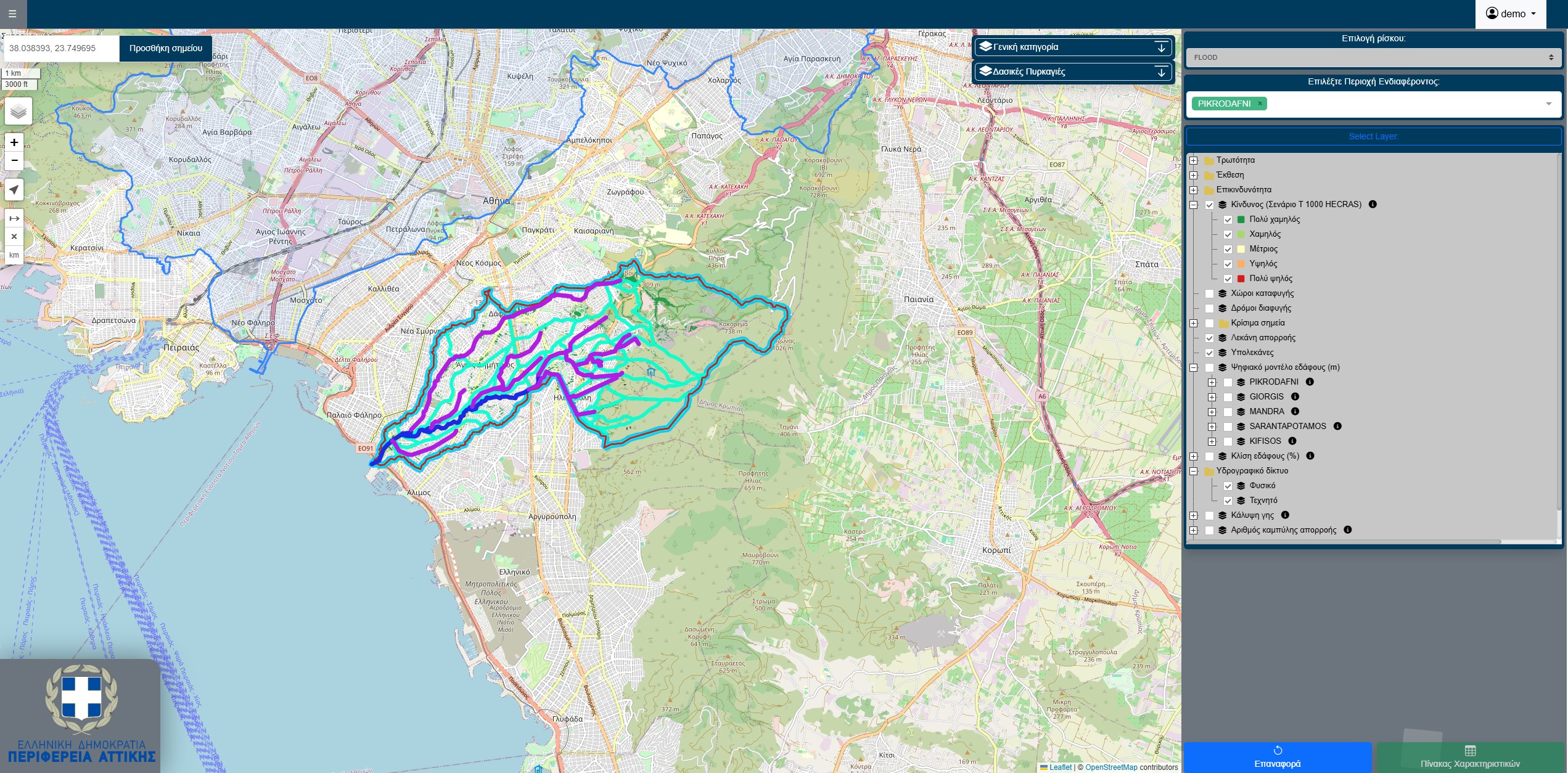
In 2021, a Programming Agreement was signed between the Prefecture of Attica and the National Observatory of Athens to conduct the research study “Earthquake, fire and flood risk assessment in the Region of Attica” (Part A) in selected and most vulnerable areas. In the framework of this research and technical work, state-of-the-art methodologies were developed and implemented that support multiparameter flood risk assessment and management planning at high spatial resolution (building block level). This work integrates different data sources, including remote sensing, in-situ measurements, field visits, and simulations, and is characterized by considerable added value, as it supports the civil protection authorities as well as all the other relevant stakeholders in the decision-making, first response, and management of floods. Furthermore, this innovative approach is transferable, adaptable, and scalable, and it was implemented in the Garyllis river basin in Cyprus, in the framework of the “EXCELSIOR” H2020 Widespread Teaming project.
https://perifereia-attica.beyond-eocenter.eu/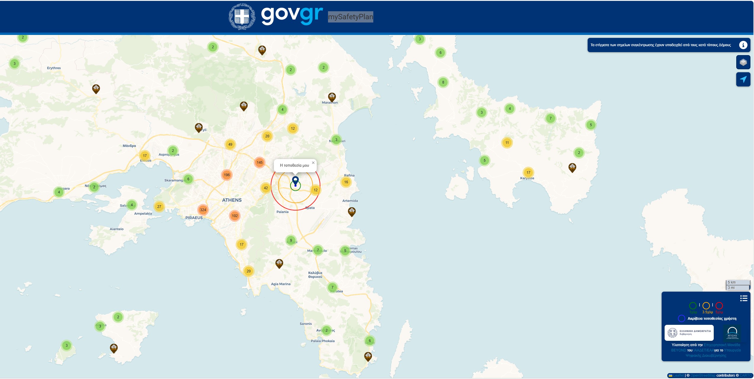
A user-friendly mobile application for civil protection purposes. By logging into the application the user finds on the map the nearest assembly points in the area in case of an earthquake. By selecting the desired point the user receives directions to the assembly point.
https://mysafetyplan.gov.gr/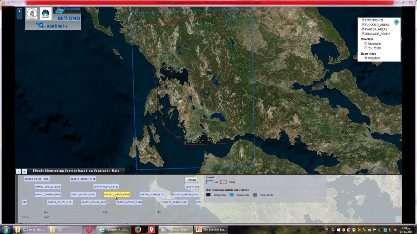
It depicts the results of the diachronic mapping of flooded areas in selected river basins of special interest, following the processing of Sentinel images from the Hellenic National Sentinel Data Mirror Site, through a fully automated process.
http://195.251.203.238/floodhubweb/a) It registers major flood events in Greece & South-Eastern Europe and publishes the flood mapping results, produced following the processing and photo-interpretation of satellite optical and radar images.
http://floodsobservatory.blogspot.gr/Alexia Tsouni, alexiatsouni@noa.gr