FireHub
The FireHUB system of the BEYOND EO Centre in the National Observatory of Athens, is an innovative, automated system for integrated forest fire management. It supports risk assessment, active fire detection, fire spread estimation, and burned area mapping, applied within the Greek territory and Beyond.
The main objective of FireHUB is to support early warning and informed decision-making in emergency situations, both at the preventive and operational levels.
The system provides a comprehensive set of services covering the entire lifecycle of a forest fire, from risk prediction to impact assessment. It includes a 24/7 Fire Monitoring Service for detecting active fire hotspots, estimating ignition points, and forecasting fire spread in near real time.
In parallel, it offers a Daily Fire Risk Forecast Map for assessing the probability of fire occurrence in the following day, as well as a long-term burned area mapping service for recording and analyzing historical data from 1984 to the present, including ignition frequency per area.
Additionally, it includes a smoke dispersion modeling service for assessing air quality as a result of active fires, as well as a Forest Fire Information System extending monitoring to broader regions such as Europe, North Africa, the Middle East, and the Black Sea.
FireHUB utilizes a wide range of satellite data collected daily from BEYOND infrastructures. Specifically, the X-/L-band receiving station is used for data from satellites such as EOS/AQUA, EOS/TERRA, SUOMI-NPP, and JPSS NOAA-20, while MSG SEVIRI data are retrieved in near-real time every 5 minutes from Meteosat satellites of EUMETSAT.
At the same time, data from the Greek Sentinel Mirror Site are integrated, providing near real-time information from Sentinel-1, Sentinel-2, and Sentinel-3 satellites.
The combined use of these sources ensures a continuous flow of highly reliable satellite observations, supporting both immediate operational monitoring and long-term fire analysis.
All FireHUB services are fully open and accessible via the web interface. They provide near real-time information as well as long-term datasets for the analysis and study of forest fires.
The system is widely used by operational and institutional stakeholders, including Fire Services, the Copernicus EMS (Risk & Recovery), ministries and civil protection authorities, forest management organizations, as well as private sector entities and local or national authorities.
Since 2018, FireHUB has been integrated into the Global Fire Monitoring Center under the United Nations International Strategy for Disaster Reduction (UNDRR).
Within this framework, the BEYOND Centre Forest Fire Information System for Europe, North Africa, the Middle East, and the Black Sea provides daily near real-time information on active fires, burned area estimates, and statistics per country and time period.
The BEYOND
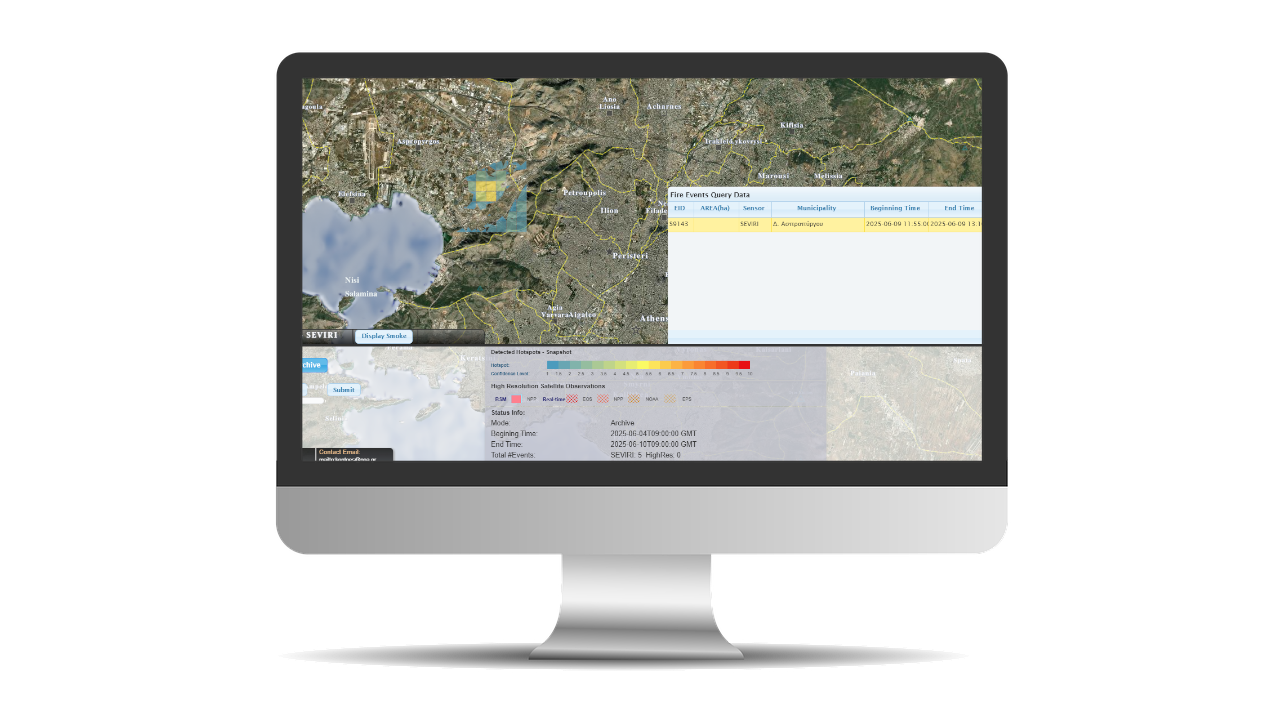
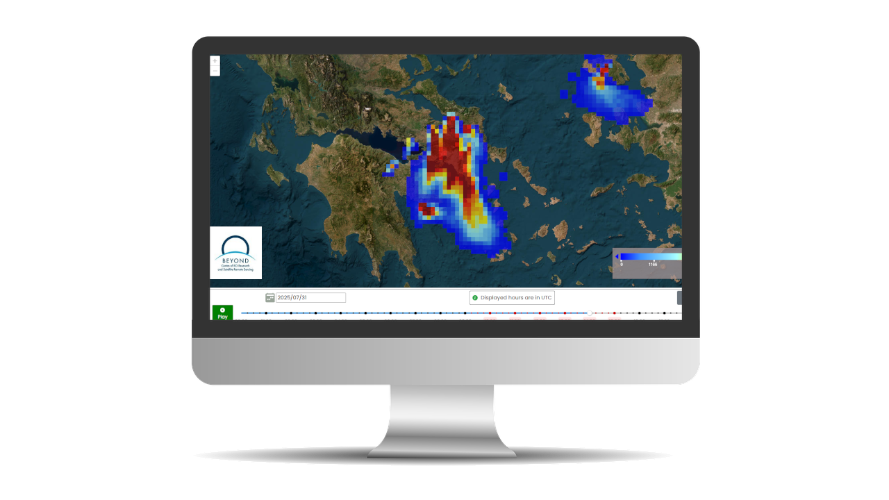
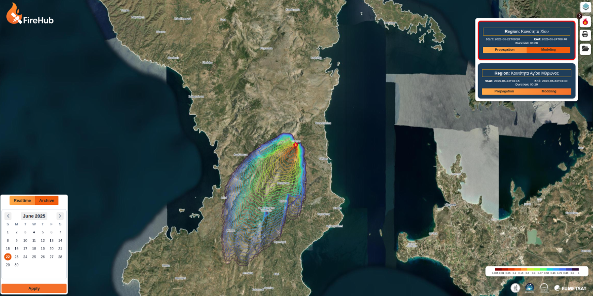
Fire Monitoring Service s an operational platform of continuous operation for detecting active fires across Greece in near real time.
It is based on fully automated processing chains that support early detection and dynamic monitoring of events. It integrates data fusion techniques, modeling, and advanced image processing algorithms developed and optimized through long-term operational use.
The service utilizes high temporal resolution satellite observations from missions such as MSG SEVIRI (EUMETSAT). It also combines atmospheric parameters such as wind, temperature and precipitation (derived from numerical weather predictions), topography, elevation, along with fuel data and risk indices. It produces active fire predictions at a resolution of 350 meters, significantly higher than the original 3.5 km resolution of MSG SEVIRI.
The platform further integrates heterogeneous geospatial datasets such as Google Earth, Corine Land Cover, and OpenStreetMap, as well as points of interest, offering a unified operational analysis environment while supporting retrospective fire investigation.
Since summer 2026, the service has been expanded with an ignition point estimation algorithm and fire spread prediction capability per event, utilizing the ForeFire model for dynamic simulation.
The
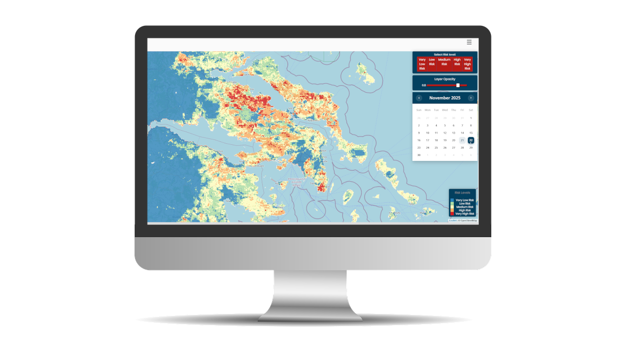
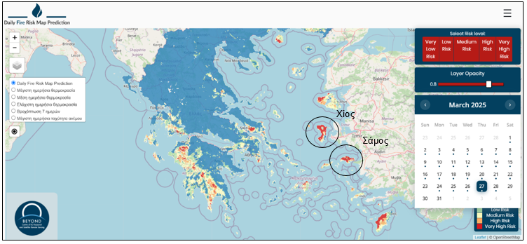
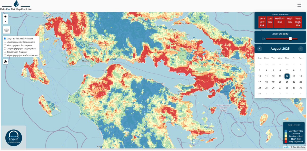
Daily Fire Risk Forecast Map provides, every day around 15:30, an interactive map depicting fire risk for the following day across Greece, with a spatial resolution of 500 meters.
Risk is expressed across five levels, from very low to very high, allowing immediate interpretation. The platform also supports displaying the user’s location on the map via location services.
The forecast is based on advanced artificial intelligence methods and a multi-model approach, using algorithms such as Random Forest, Extra Trees, XGBoost, and neural networks, selected based on performance.
Each estimate relies exclusively on data available up to the previous day and incorporates geospatial and meteorological features such as temperature, wind, and precipitation forecasts, Copernicus DEM, Corine Land Cover, vegetation indices (NDVI, EVI), NASA MODIS land surface temperatures, and historical fire data from the long-term burned area mapping service.
The system’s effectiveness has been validated through extensive testing on past datasets, demonstrating high accuracy in fine-scale risk estimation.
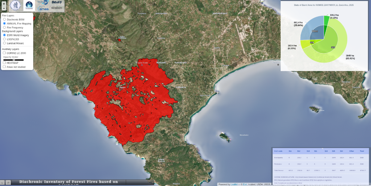
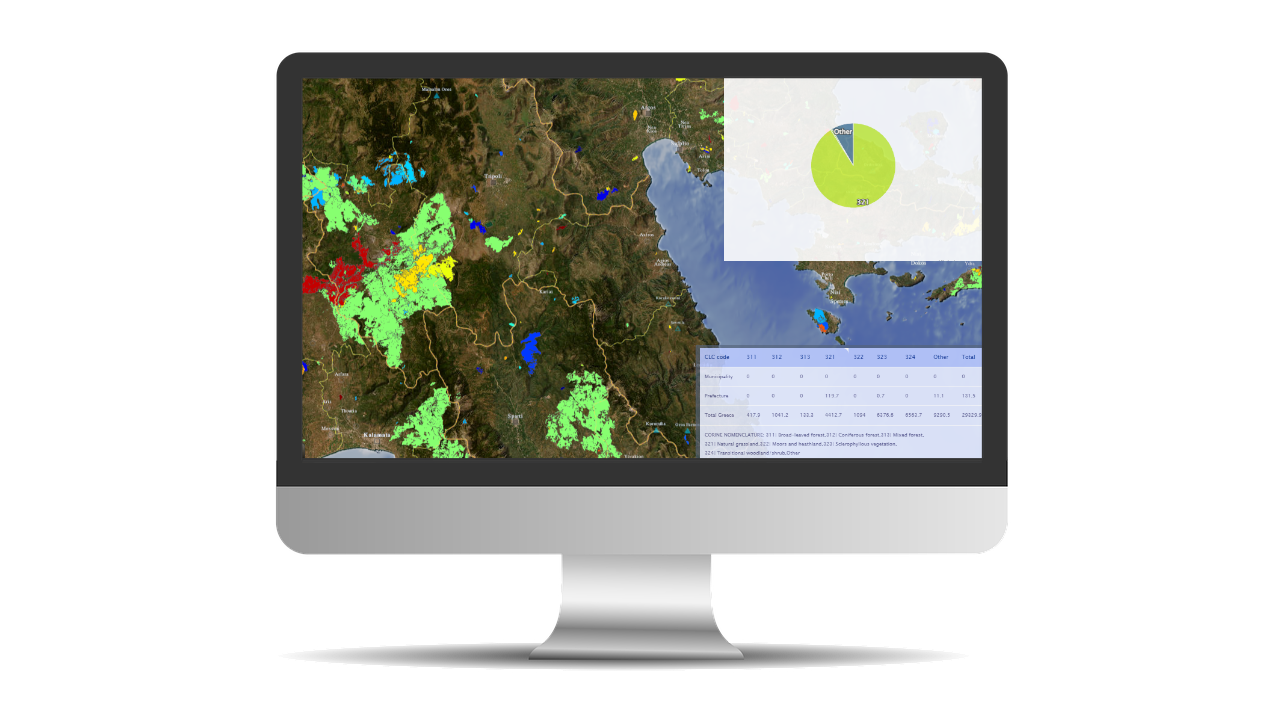
The Diachronic Burned Scar Mapping service was initially developed as an offline multi-sensor processing chain and now operates as an online platform with full coverage of the Greek territory.
It applies multi-temporal analysis to estimate burned areas and environmental impacts from 1984 to the present. It also provides ignition frequency per region, enabling spatial and temporal fire recurrence analysis.
The algorithm is based on an adaptation of BSM-NOA and the methodology of Liu et al. (2014) using Level Set Methods, with additional optimizations for error reduction and heterogeneous satellite data adaptation.
The service uses data from Landsat, SPOT, IKONOS, FORMOSAT, as well as Sentinel-2 and Sentinel-3, ensuring full spatial and temporal coverage, supported by BEYOND infrastructure and the Greek Sentinel Mirror Site.
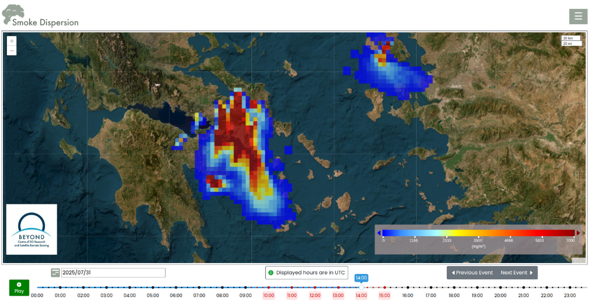
Biomass burning and forest fires are directly linked to climate change impacts, as increasing global temperatures are intensifying their frequency and severity. Emitted particles play a critical role in climate regulation, affecting radiation transfer and cloud formation processes.
At the same time, exposure to smoke is associated with significant public health impacts, as even highly localized events can affect large regions through particulate transport.
Smoke plume evolution and dispersion are governed by atmospheric factors such as wind fields, atmospheric stability, mixing height, as well as fire intensity, duration, and initial plume rise. Forecasting is implemented through numerical simulations.
Detailed fire hotspot information is provided by the BEYOND 24/7 Fire Monitoring Service, updated every five minutes via MSG SEVIRI, serving as key input for the forecasting models.
Smoke dispersion is then simulated using the FLEXPART Lagrangian dispersion model, driven by meteorological data from the operational WRF-ARW model over Greece.
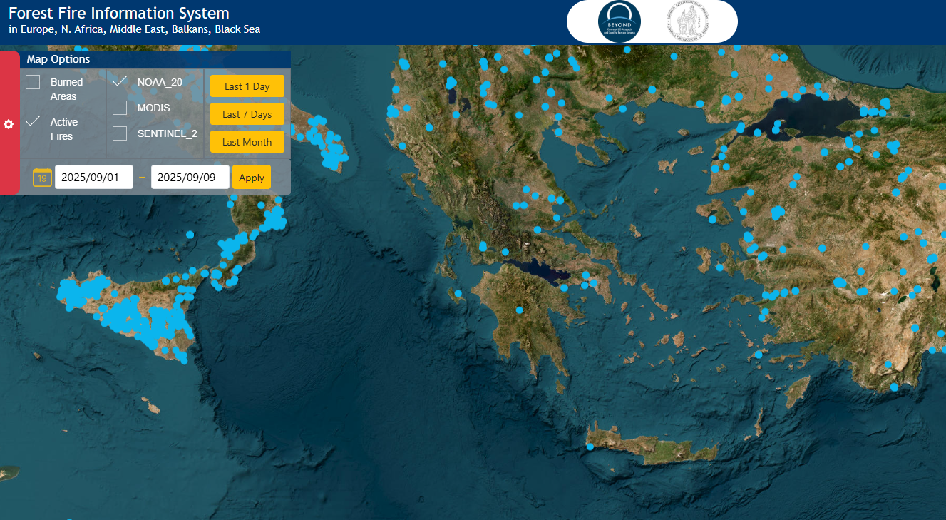
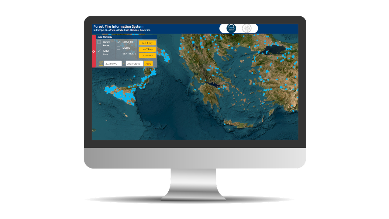
The Forest Fire Information System of the BEYOND EO Centre is a fully automated, continuously operating system for detecting active fire hotspots and mapping burned areas. Its operational coverage extends beyond Greece to Europe, North Africa, the Black Sea, and the Middle East.
The Centre processes satellite data acquired from the ground receiving station at BEYOND facilities in Penteli, as well as from the Greek Sentinel Mirror Site. Near real-time data processing from satellites such as SUOMI-NPP, NOAA-20, and MODIS provides reliable and up-to-date fire information, supporting fire services and crisis management centers across the EU and neighboring regions.
The system provides active fire maps, hotspot location and extent data, as well as estimates of fire intensity and risk magnitude. It also offers detailed statistics on affected areas based on land use/land cover categories, per fire event, country, and time period.
Long-term data are organized into structured data cubes, enabling further analysis and supporting studies of fire behavior and occurrence probability across the Mediterranean ecosystem.
Smarter Fire Mapping for Faster and More Reliable Decision-Making
Key innovations incorporated into the state-of-the-art algorithms include advanced histogram matching techniques, significantly improving classification of burned and unburned areas across large geographic regions.
The system integrates a wide set of indices enabling more accurate burn severity assessment and improved burned area extraction.
It combines Level Set Methods (LSM), one of the most advanced image segmentation approaches, with advanced database post-processing procedures. These enable unique identification of each fire event through assignment of a fire event ID and the creation of unified burned areas by merging multi-day observations.
Additionally, the system is designed with high algorithmic adaptability, allowing processing of data from any optical sensor, provided it captures spectral information in the visible red, near-infrared, and shortwave infrared bands.
Overall, these techniques enhance the system’s ability to provide consistent, reliable, and high-accuracy burned area mapping across different spatial and temporal scales.
Charalampos Kontoes, kontoes@noa.gr , Themistocles Herekakis, therekak@noa.gr, Dimitrios Vallianatos, dvallianatos@noa.gr