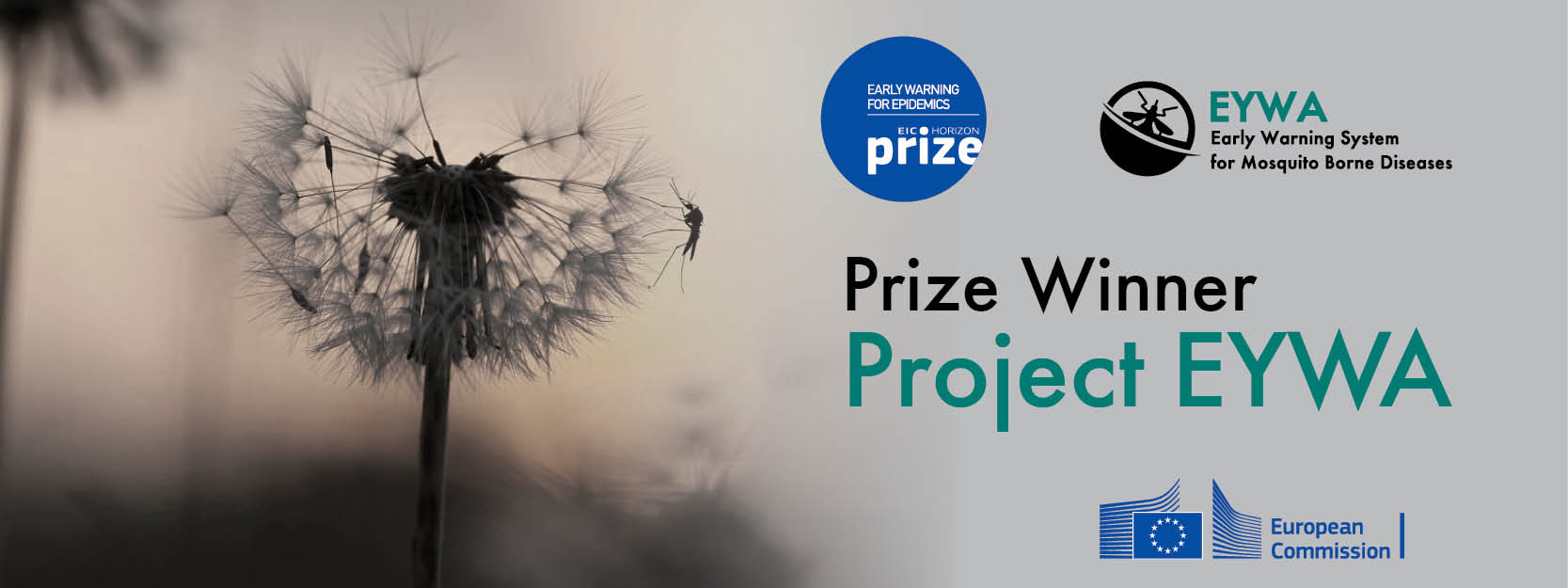
Early Warning System for Mosquito Borne Diseases (EYWA)
Vector-borne diseases (VBDs) are illnesses transmitted by mosquitoes, ticks, and other insects. They cause more than 700,000 deaths every year and make up over 17% of all infectious diseases worldwide. Mosquito-borne diseases (MBDs) such as malaria, dengue, Zika, chikungunya, yellow fever, and West Nile virus (WNV) are responsible for the majority of those deaths, making mosquitoes the deadliest animals in the world. VBDs and subsequently MBDs are most common in tropical and subtropical regions, but they are now appearing in new areas.
Climate change, rapid urbanization, global travel, and the ability of insects to adapt are helping vectors spread. In several regions of Europe, and especially in Greece, WNV infections in humans and animals have been recorded repeatedly from 2010 to 2021, with an unusually high number in 2018. As temperatures rise, insects are expanding into new regions and remaining active for longer periods. This increases the risk of outbreaks in places that were previously unaffected.
The BEYOND Center of Excellence contributes towards that problem by developing an operational Early Warning System (EWS) that has been running and evolving since 2022. It includes two main modules: one that predicts mosquito abundance for several mosquito species, and another that predicts mosquito-borne disease risk for multiple diseases. The system uses large volumes of Earth Observation (EO) data to estimate environmental and climatic conditions, ground morphology, and land use, factors that strongly influence mosquito populations and the spread of MDBs. At its core, the EWS uses advanced machine learning and deep learning models to produce short-term predictions for the near future. This operational EWS supports health authorities by helping them plan actions, strengthen public-health responses, and take preventive measures to reduce the spread of MBDs. It also contributes to key Sustainable Development Goals (SDGs), including good health and well-being (SDG 3) and climate action (SDG 13).


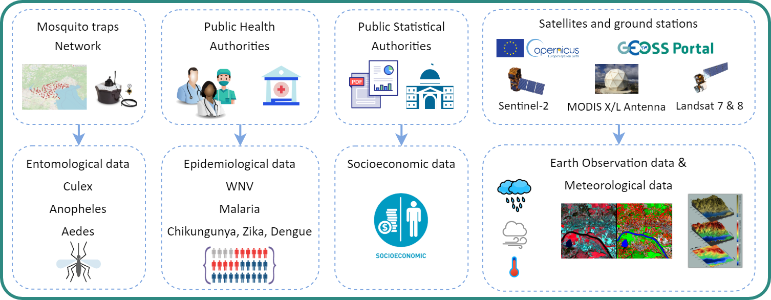
The main objectives of EYWA lie with the need to offer a scalable, reliable, sustainable and cost-effective Early Warning System (EWS) relying on big Earth Observation (EO) data in conjunction with environmental, climatic and meteorological essential parameters, socioeconomic and population data, ecosystem and morphological related parameters, as well as epidemiological and entomological data to forecast and monitor MBDs.
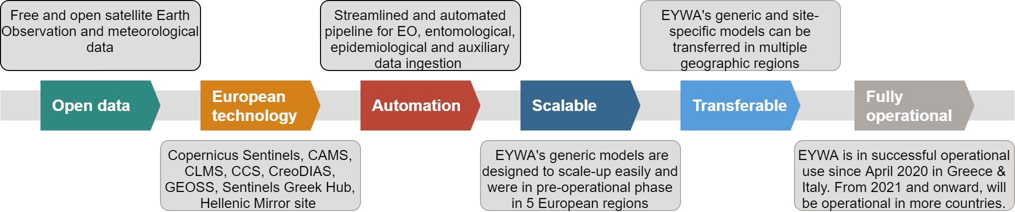
Full series of Entomological and Epidemiological Data from the five European countries members of the consortium are integrated so far, including open data introducing environmental essential parameters, time series Meteo, GEOSS portal data e.g. edministrative and socioeconomic data, topographic data, Copernicus Core Service data (C3S, ERA5, IMERG, CLMS, etc.), Copernicus, and Copernicus contributing missions, EO derived proxies from Sentinels and Landsat TM.
Ultimately:
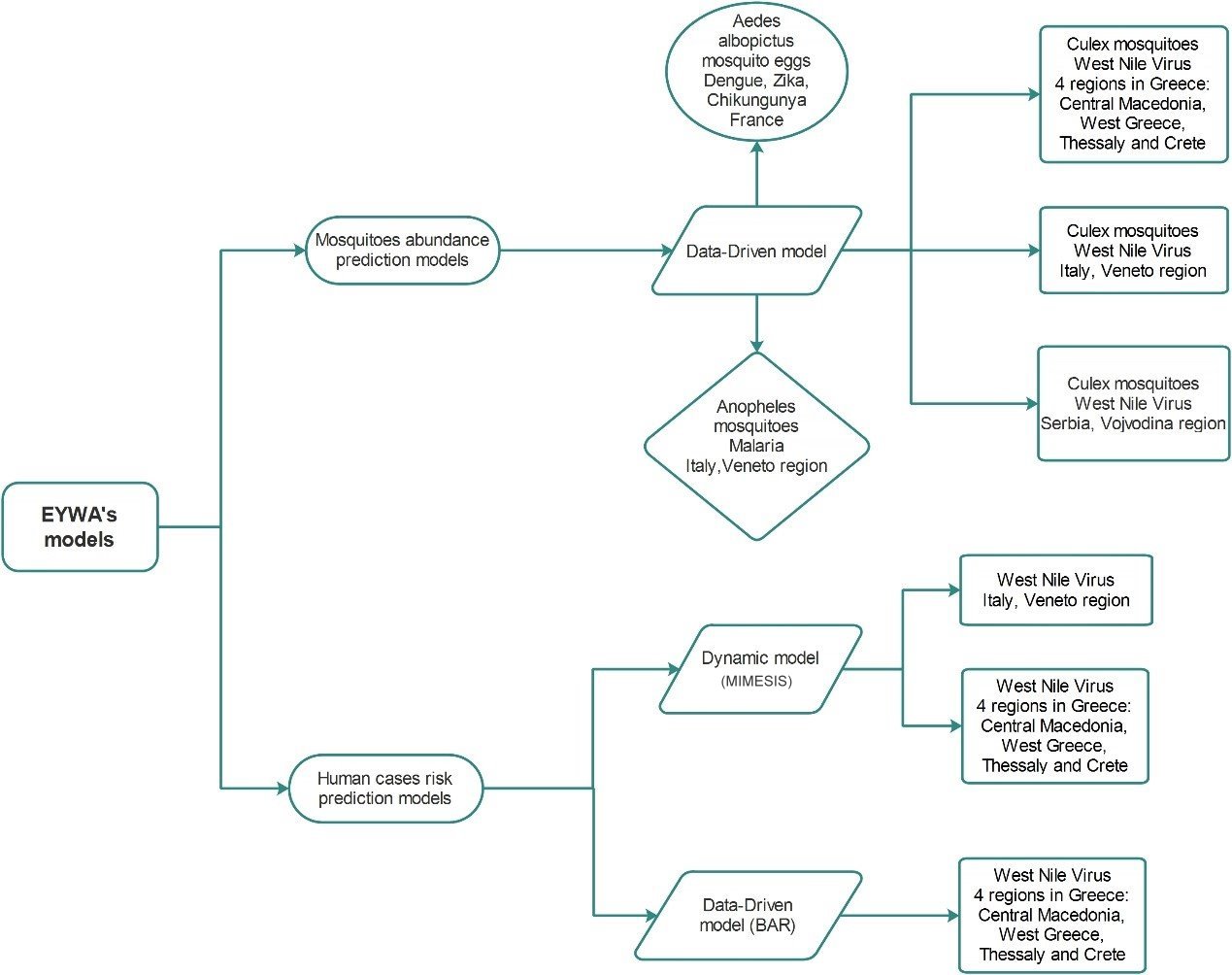
MAMOTH is a data-driven machine learning
framework, designed to predict mosquito abundance for the near future. The framework
relies on satellite-derived Earth Observation data, including environmental indices,
meteorological variables, and geomorphological information, as well as entomological
surveillance measurements. MAMOTH does not depend on a specific mosquito species and is
not confined to a single region. Instead it is built to be generic, mosquito-genus
agnostic and transferable.
At its core MAMOTH reframes the mosquito abundance forecasting problem as an ordinal
classification problem. The model is designed to predict mosquito classes rather than
mosquito counts, making predictions both more robust to outliers and easier for public
health authorities to interpret. MAMOTH is designed to automatically select the most
informative features and to tune its own hyper-parameters, allowing it to adjust to
different mosquito genera, landscapes, and climatic conditions.
MAMOTH currently supports multiple regions across Europe and Africa via its web
platform: http://epidemics.space.noa.gr:8081/, producing timely
predictions that could be accessed by health authorities.
| MAMOTH Model Reporting Region | Mosq | Data | Predictions Avail |
|---|---|---|---|
| Ghana (Africa) | Anopheles | 2017 - 2019 | Week 12 - 2023 |
| Ivory Coast (Africa) | Aedes | 2012 - 2020 | 2022 - 2025 |
| Occitanie (France) | Culex | 2007 - 2022 | 2021 - 2025 |
| Grand-Est (France) | Aedes | 2017 - 2022 | 2021 - 2025 |
| Corsica (France) | Aedes | 2017 - 2022 | 2021 - 2025 |
| Baden Württemberg (Germany) | Culex | 2010 - 2025 | 2021 - 2025 |
| Central Macedonia (Greece) | Culex | 2011 - 2025 | 2022 - 2025 |
| Thessaly (Greece) | Culex | 2011 - 2025 | 2022 - 2025 |
| Western Greece (Greece) | Culex | 2011 - 2025 | 2022 - 2025 |
| Crete (Greece) | Culex | 2011 - 2025 | 2022 - 2025 |
| Trentino (Italy) | Aedes | 2011 - 2025 | 2022 - 2025 |
| Trentino (Italy) | Anopheles | 2011 - 2025 | 2023 - 2025 |
| Trentino (Italy) | Culex | 2011 - 2025 | 2023 - 2025 |
| Veneto (Italy) | Anopheles | 2010 - 2025 | 2021 - 2025 |
| Veneto (Italy) | Culex | 2010 - 2025 | 2020 - 2025 |
| Vojvodina (Serbia) | Culex | 2010 - 2025 | 2021 - 2025 |
| Pancevo (Serbia) | Culex | 2015 - 2022 | - |
| Thailand | Aedes | 2022 | 2022 |
DVI is a data-driven machine learning
framework designed to predict mosquito-borne diseases and uncover their key transmission
drivers using explainable AI. The model is fusing satellite-derived Earth Observation
data such as environmental indices, meteorological data, and geomorphological
characteristics, with socio-economic indicators and mosquito abundance predictions from
the MAMOTH model (where available). It combines those features with historical
epidemiological MBD data to build a generic, transparent, and transferable machine
learning pipeline.
DVI is built to handle diverse regions with vastly different needs. In areas where MDB
is an emerging problem and the cases are relatively low, the model is adapted to predict
MDB risk, meaning the probability that at least one case will appear. In areas where
they are suffering from MDB and the cases are very high, DVI can reframe the case
prediction problem as an ordinal classification problem, making the predictions more
accurate and more helpful to public health authorities. A key component of DVI is its
explainability layer , which quantifies how each feature influences model predictions.
The model also incorporates ensemble-based uncertainty estimation, producing metrics
that inform how confident the system is in each prediction. Overall, DVI provides a
robust, transparent, and operationally deployable risk-forecasting tool for health
authorities, enabling proactive interventions against mosquito-borne diseases.
DVI currently supports multiple regions across Greece and Cameroon via its web
platforms: http://epidemics.space.noa.gr:8081/, https://cameroon.beyond-eocenter.eu/ producing timely
predictions that could be accessed by health authorities.
| Region | Disease | Data | Predictions Avail | Data Resolution |
|---|---|---|---|---|
| Veneto (Italy) | WNV | 2008 - 2019 | - | LAU1 / Daily |
| Greece | WNV | 2010 - 2021 | 2025 | 1x1km / Daily |
| Extreme Nord (Cameroon) | Malaria | 2015 - 2024 | 2025 - 2026 | NUTS3 (equivalent) / Monthly |
| Nord (Cameroon) | Malaria | 2015 - 2024 | 2025 - 2026 | NUTS3 (equivalent) / Monthly |
EYWA achieved Technology Readiness Level – TRL 7 (system prototype demonstration in operational environment) in the development of a radically new technique for modelling and predicting mosquito – borne outbreaks across different temporal and spatial scales in Europe. The system reached this milestone and produces results that are published in a Web GIS Platform available to the National Health Organizations and Public Authorities, as well as Research Institutes and Private Companies (end users).
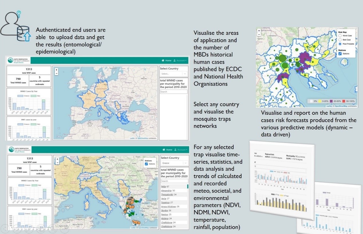
EYWA GIS Platform is a niche
state-of-the-art tool, in the hands of the National Health Organizations and Public
Authorities, which publishes knowledge derived from collected data and models in regards
to the mosquito population and forecasted risks for mosquito – borne disease outbreaks.
Therefore, EYWA is a conducive tool to enhance decision making towards the prevention of
outbreaks and mitigation of their impact on local, regional and global scale.
Additionally, the platform is a key lever for organizations involved in mosquito
elimination efforts, facilitating the optimal management of the huge combating resources
and capacities deployed seasonally (field inspectors, analysts and vehicles, spraying
helicopters and drones, thousands of mosquito breeding sites), saving hundreds of
millions of Euros for the operations, by indicating targeted actions for
implementation.
The platform leveraging European investments and open standards, seamlessly integrating
open Data / IP / Hubs / and Portals (e.g. Copernicus Hubs, Copernicus Portals, GEOSS,
National Mirror Sites, DIAS, etc.) and delivers information using open OGC standards.
Relying on the advancements in
exploiting big EO, and ICT / AI sciences, and leveraging on the use of existing EU
investments such as Copernicus, GEO/EuroGEO, and other European infrastructures
including existing satellite data hubs and repositories, DIAS platforms, Cloud HPC, Open
DataCubes, etc., EYWA becomes a game changer in the domain of epidemics.
In line with the open science and open innovation principles EYWA delivers an
innovative, scalable, reliable, transferable, and integrated solution at various
spatio-temporal scales (municipality -> regional -> country -> continent level). It
consists a fully operational and radically new technique for modelling and predicting
mosquito–borne outbreaks across different temporal and spatial scales in Europe with the
Technology Readiness Level ranging from 7 – 9 (system prototype demonstration in
operational environment).
In the hands of National Health Organizations, Public Authorities and other Users, and
through a continuous co-design and co-creation approach, EYWA intends to become a
state-of-the-art tool and a European standard in the domain of epidemics for Vector
Borne Diseases.
A case study about EYWA was developed for the European Climate and Health Observatory of the European Environment Agency, entitled “Managing mosquito borne disease through EYWA: an European tool to support public health authorities in preventing epidemics”
JRC Centre for Advanced Studies (CAS) brings together Joint Research Centre (JRC) and external scientists and researchers in a single unit, addresses specific cross disciplinary research topics with a longer term perspective on EU policy, promotes and develops research collaboration with top universities and institutes worldwide.
Epidemics: Dynamics and Control (EPICO) focuses on respiratory infectious diseases with pandemic potential (e.g. influenza, corona viruses) and emerging vector-borne diseases (e.g., Zika, Chikungunya, Dengue, West Nile virus) that pose a major global health threat, aiming to develop a framework based on mathematical and statistical methods and on data derived from routine and on modern space surveillance systems. It studies aspects of spatiotemporal dynamics, seasonality, the One-Health approach, transmission modes, waning immunity, the immuno-epidemiology of the disease, early warning, and the assessment of pharmaceutical interventions that may inform public health decision makers.
Dr Kontoes from BEYOND Centre of Earth Observation Research and Satellite Remote Sensing of the National Observatory of Athens, had the opportunity to present, on the 14th of October 2021, the EarlY WArning System for Mosquito-Borne Diseases (EYWA), a game changer in the domain of epidemics that was developed under the flag of EuroGEO Action Group, to the JRC’s Centre for Advanced Studies (CAS) in the framework of Epidemics: Dynamics and Control (EPICO) project.

More info:
CAS10_EPICO_KickOff_Meeting_AbstactsThe GEO Health Community of Practice is a global network of governments, organizations, and observers. It seeks to use environmental observations to improve health decision-making at the international, regional, country, and district levels.
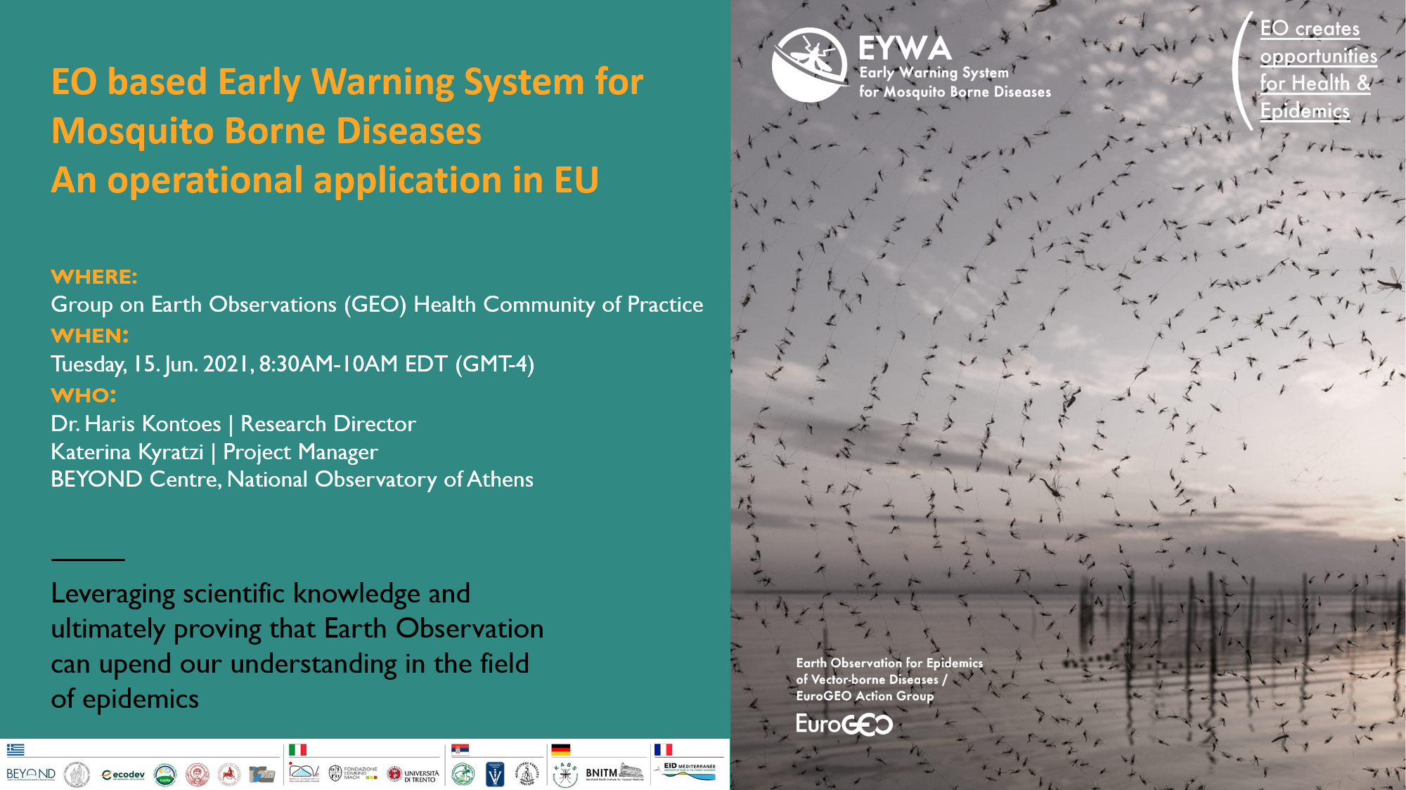
The Group on Earth Observations (GEO) Health Community of Practice was pleased to host the community teleconference on Tuesday, June 15th from 8:30AM-10AM EDT (GMT-4). This teleconference focused on infectious disease research applications. Haris Kontoes (Research Director, National Observatory of Athens) & Katerina Kyratzi (EYWA Project Manager, National Observatory of Athens) provided an overview of the Early Warning System for Mosquito borne diseases (EYWA) of the EuroGEO Action Group’s Earth Observation for Epidemics of Vector-borne Diseases (National Observatory of Athens / BEYOND Centre of Earth Observation Research and Satellite Remote Sensing).
Download the full presentation here
Where: ESA Living Planet Symposium 2025, Vienna, Austria
Link: ESA Living Planet Symposium 2025
When: 23–27/06/2025
Where: ESA EO4Health User Forum 2025, Paris / Online
Link: ESA EO4Health User Forum 2025
When: 22–25/09/2025
Where: Copernicus Health Hub
Link: 2025: A Year of Growth for the Copernicus Health Hub
Where: Healthsites.io Seminar
Link: Healthsites.io Seminar Agenda
When: 07/01/2025
Where: EEA Webinar
When: 20/11/2025
Where: Copernicus Health Hub Event
When: 08/12/2025
Where: Group on Earth Observations (GEO) Health Community of Practice
Link: http://www.geohealthcop.org/workshops/2023/6/9/telecon-eurogeo
Presentation Title: “EYWA: An established Early Warning System to Address World Wide Epidemics Crisis caused by the Mosquito Borne Diseases in Operational Context”
When: 09/06/2023
Where: Eurisy Members’ Corner | Virtual Webinar
Presentation Title: “Unveiling the EYWA System, from the challenge…to the solution!”
When: 26/05/2023
Where: GEO WEEK 2022
Link: https://www.earthobservations.org/geoweek2022.php
Presentation Title: “EYWA: An established Early Warning System to Address World Wide Epidemics Crisis caused by the Mosquito Borne Diseases in Operational Context”
When: 01/11/2021
Where: ITU /WMO/UNEP Workshop on Artificial Intelligence for Natural Disaster Management
Link: https://www.itu.int/en/ITU-T/Workshops-and-Seminars/2022/1024/Pages/default.aspx
Presentation Title: “EYWA: An established Early Warning System to Address World Wide Epidemics Crisis caused by the Mosquito Borne Diseases”
When: 24/10/2022
Where: EU Global Action on Space: Current and future opportunities for EU-Africa cooperation in the Space domain
Presentation Title: “EYWA: A key tool to the epidemics arsenal”
When: 06/09/2022
Where: Emerging Earth Observation technologies in support of Health surveillance: From scientific data to knowledge, e-shape Webinar
Link: https://e-shape.euimages/webinars/SC2_agenda_F.pdf
Presentation Title: “EYWA: A key tool to the epidemics arsenal”
When: 08/06/2022
Where: Earth Observation solutions for sustainable development: Hands-on e-shape services
Presentation Title: “EYWA: A key tool to the epidemics arsenal”
When: 07/06/2022
Where: United Nations/Ghana/PSIPW - 5th International conference on the use of space technology for water resources management
Link: https://www.unoosa.org/oosa/en/ourwork/psa/schedule/2022/un-Ghana-water.html
Presentation: “EYWA: A key tool to the epidemics arsenal”
When: 11/05/2022
Where: Πανελλήνιο Συνέδριο Δημόσιας Υγείας 2022
Link: https://www.events-free-spirit.gr/dimosias-ygeias-2022
Presentation Title: “Πρόγραμμα Ερευνώ-Καινοτομώ "ΕΜΠΡΟΣ": Ολοκληρωμένο σύστημα πρόβλεψης κρουσμάτων WNV. Ερευνητική Δράση που υποστηρίζει την δημιουργία καινοτομίας του επιχειρησιακού προγράμματος EYWA για την αντιμετώπιση νοσημάτων από κουνούπια”
When: 01/03/2022
Where: Joint Research Center – European Commission
Link:
Presentation Title: “EYWA: A key tool to the epidemics arsenal”
When: December 2021
Where: EO4HEALTH Community of Practice
Link:
Presentation Title: “EO based Early Warning System for Mosquito Borne Diseases An operational application in EU”
When: June 2021
Where: EO4GEO
Link:
Presentation Title: “EO based Early Warning System for Mosquito-Borne Diseases. An operational application in EU”
When: June 2021
Where: EXCELSIOR 2021
Link:
Presentation Title: “EYWA: EO based Early Warning System for Mosquito Borne Diseases An operational application in EU”
When: June 2021
EYWA at WHO podcast
https://eyeonyellowfever.libsyn.com/space-a-new-frontier-in-public-health
22/05/2021 - Υψώνεται «ασπίδα» προστασίας
κατά του ιού του Δυτικού Νείλου και των κουνουπιών
Click here for EN
translation
![]() 19/05/2021 - Σύστημα που βασίζεται σε μαθηματικά
μοντέλα προβλέπει την εκδήλωση του ιού του Δυτικού Νείλου
19/05/2021 - Σύστημα που βασίζεται σε μαθηματικά
μοντέλα προβλέπει την εκδήλωση του ιού του Δυτικού Νείλου
![]() 18/03/2021 - Σύστημα προειδοποίησης για τον ιό
του Δυτικού Νείλου
18/03/2021 - Σύστημα προειδοποίησης για τον ιό
του Δυτικού Νείλου
![]() 09/03/2021 - Το Σύστημα Έγκαιρης Ειδοποίησης για τον
ιό του Δυτικού Νείλου
09/03/2021 - Το Σύστημα Έγκαιρης Ειδοποίησης για τον
ιό του Δυτικού Νείλου
![]() 18/03/2021
- Σύστημα προειδοποίησης για τον ιό του Δυτικού Νείλου
18/03/2021
- Σύστημα προειδοποίησης για τον ιό του Δυτικού Νείλου
![]() 27/07/2020 - Η
Τεχνητή Νοημοσύνη φύλακας-άγγελος από τον ιό του Δυτικού Νείλου
27/07/2020 - Η
Τεχνητή Νοημοσύνη φύλακας-άγγελος από τον ιό του Δυτικού Νείλου
MAMOTH: An Earth Observational Data-Driven Model for Mosquitoes Abundance Prediction https://doi.org/10.3390/rs13132557
Satellite Earth Observation Data in Epidemiological Modeling of Malaria, Dengue and West Nile Virus: A Scoping Review, https://doi.org/10.3390/rs11161862