GROUP 


On the 28th of November, Operational Unit “BEYOND Centre of Earth Observation Research and Satellite Remote Sensing” of the National Observatory of Athens, in collaboration with PRAXI Network/FORTH, the Higher School of Communication of Tunis (SUP’COM) and the IEEE-GRSS Tunisia Chapter organized the Capacity Building Workshop in Tunis, “EO and Copernicus data & Services, Soil Degradation and Water Resources”.

Stakeholders from public and private entities, Universities and Local Authorities, along with BEYOND’s representatives, Mrs Marietta Papakonstantinou (Project Manager in FPCUP program) and Dr. Nikos Stathopoulos (Project Manager in Soil Projects), presented the current status on Soil Degradation and Water Resources, identified the needs and gaps and set up the basis for future collaboration. 

The event aimed at the EO Capacity building in Tunisia, underlining the importance of sharing experiences and exchanging good practices for a fruitful cross border collaboration in the framework of the Copernicus User Uptake Activities.

More info: https://www.copernicus-user-uptake.eu/events/events-details/fpcup-capacity-building-workshop-in-tunisia-eo-and-copernicus-data-services-604


greece japan flood Mitigation on line workshop 2023 


On October 27, 2023, “Greece - Japan Flood Mitigation Online Workshop” was co-organized by the National Research Institute for Earth Science and Disaster Resilience (NIED) of Japan and the Government of Greece to reflect back on the severe flooding events that occurred in central Greece this September and for the Japanese experts to share how flood management and mitigation measures are implemented in Japan.

The workshop began with welcoming remarks by Prof. Kaoru Takara, President of NIED who sent his condolences to the affected people in Greece and emphasized the importance of cross-sectoral collaboration among government, research institutes and private sector; giving an example of the Japan Hub of Disaster Resilience Partners (JHoP) in which NIED serves as the secretariat.

The welcoming remarks was followed by presentations from Greek representatives that gave a briefing on the post-flood situation and the water and flood management in Greece.

In particular, Alexia Tsouni, Research Associate of the Operational Unit BEYOND EO Centre of IAASARS, NOA participated in the Workshop focusing on the one hand to the operational FloodHub service providing flood early warning and monitoring, and on the other hand to the multi-parameter high-resolution flood risk assessment in the Region of Attica. She highlighted the cooperation of BEYOND EO Centre with the Regional and Municipal Authorities, the Fire Service, the Civil Protection Associations, as well as the capacity building and the support provided by BEYOND EO Centre for the implementation of civil protection exercises and educational activities.

The workshop continued with presentations from Japanese experts from the Ministry of Land, Infrastructure, Transport and Tourism (MLIT), the International Centre for Water Hazard and Risk Management (ICHARM) and NIED on flood management policy in Japan, research on flood hazard risk analysis, landslide/debris flow management, and disaster information management.

Towards the end of the workshop, a Q&A session was held, followed by active discussions on various ways on how flood modeling, early warning and coordination can further be improved. In addition, future steps to identify areas of possible medium and long term collaborations were suggested from both sides.

The workshop attracted a total of about 60 people from Greece and Japan, including two ministers, deputy ministers, other high-level officials from line agencies and representatives from academia. Japanese Ambassador to Greece also attended the workshop and provided the opening message.


More info: https://www.bosai.go.jp/e/news/2023/20231106.html


Untitled design


Νέα! ημερομηνία διεξαγωγής: 23-24/11/2023

Νέα! προθεσμία δήλωσης συμμετοχής: 20/11/2023

Με ιδιαίτερη χαρά σας ενημερώνουμε ότι η Επιχειρησιακή Μονάδα BEYOND του ΙΑΑΔΕΤ/ΕΑΑ σε συνεργασία με το Δίκτυο ΠΡΑΞΗ/ITE συνδιοργανώνουν διαδικτυακό Appathon, με τίτλο "Copernicus Innovative Solutions (Natural Disasters, Agriculture, Health)", με νέα ημερομηνία διεξαγωγής 23-24/11/2023, στο πλαίσιο του ευρωπαϊκού προγράμματος FPCUP.

Η θεματολογία του Appathon επικεντρώνεται σε τρεις (3) Θεματικές: Φυσικές Καταστροφές, Υγεία και Γεωργία. Οι ενδιαφερόμενοι καλούνται να συμμετέχουν προκειμένου να σχεδιάσουν λύσεις με χρήση δορυφορικών δεδομένων από την πλατφόρμα CREODIAS (Copernicus DIAS - Copernicus Data and Information Access Service), η οποία θα τους παρέχεται δωρεάν.

Η συμμετοχή στο Appathon είναι δωρεάν και θα απονεμηθούν τρία (3) χρηματικά βραβεία (ένα για κάθε Θεματική) αξίας 2000 ευρώ, έκαστο. Επιπλέον, οι 3 νικητές θα επωφεληθούν από προσφερόμενες υπηρεσίες ‘Coaching for pitching to investors’!

Νέα! Προθεσμία δηλώσεων συμμετοχής έως και την Δευτέρα, 20 Νοεμβρίου, στις 17:00 (CET), 18:00 (Ώρα Ελλάδος)

Για περισσότερες πληροφορίες και Δηλώσεις συμμετοχής παρακαλούμε επισκεφθείτε την ιστοσελίδα του Appathon: http://beyond-eocenter.eu/fpcup-appathon/


capacity building workshop tunisia


An event that aims at the EO Capacity building in Tunisia, is being organized by the Operational Unit “BEYOND Centre of Earth Observation Research and Satellite Remote Sensing” of the National Observatory of Athens, in collaboration with PRAXI Network/FORTH, in Tunis on November 28, 2023, at 09:00-16:00 Tunisia time.

The event is being organized with the support of the Higher School of Communication of Tunis (SUP’COM) and the IEEE-GRSS Tunisia Chapter. EO is a valuable tool for monitoring different facets of sustainable development, such as agriculture and food productivity, water management, air quality, clean energy and climate change. Specifically, during the event the Thematics of Soil Degradation and Water Resources will be introduced to relevant stakeholders in Tunisia, enhancing their knowledge acquired on the existing capacities, skills and needs. The event will be hybrid.

For online participation registration is required and physical presence is possible on personal invitation. Stay tuned!

The event is being organized in the framework of the FPCUP (Caroline Herschel Framework Partnership Agreement) Project.

Read the full agenda here  


unnamed

The Operational Unit BEYOND Center (http://www.beyond-eocenter.eu/) for Earth Observation Research and Satellite Remote Sensing of the Institute of Astronomy and Astrophysics, Space Applications and Remote Sensing of the National Observatory of Athens is seeking to hire a highly skilled and motivated Senior Expert on Energy Sector to join our team, contributing to implementation of the  Destination Earth DESP Use Case “Destination Renewable Energy”.

seismic interferogram

Δορυφορική συμβολομετρική απεικόνιση του πεδίου εδαφικής παραμόρφωσης από τον σεισμό στo Νότιο Ιράν (Μ5.8, 17-10-2023, 04:59:23 UTC).

Εδαφική παραμόρφωση από τον σεισμό Μ5.8, στο Νότιο Ιράν στις 17 Οκτωβρίου 2023, 04:59:23 UTC, καταγράφηκε από την υπηρεσία geObservatory της Επιχειρησιακής μονάδας «Κέντρο Επιστημών Παρατήρησης της Γης και Δορυφορικής Τηλεπισκόπησης BEYOND» του ΙΑΑΔΕΤ/ΕΑΑ Εθνικού Αστεροσκοπείου Αθηνών. Συμβολογράφημα καθοδικής τροχιάς του δορυφόρου Sentinel-1, δημιουργήθηκε με χρήση εικόνων από τις 6 Οκτωβρίου 2023 και 18 Οκτωβρίου 2023. Στο συμβολογράφημα κάθε κροσσός συμβολής αντιστοιχεί σε εδαφική παραμόρφωση ίση με 2.8 εκ. Όλα τα διαφορικά συμβολογράμματα που σχετίζονται με τον σεισμό, είναι διαθέσιμα στην ιστοσελίδα του geΟbsevatory (http://geobservatory.beyond-eocenter.eu/).


First co-seismic interferogram of Southern Iran earthquake (Μ5.8, 17-10-2023, 04:59:23 UTC).

Co-seismic deformation from Μ5.8 Southern Iran earthquake in October 17, 2023, 04:59:23 UTC, was mapped by the geObservatory service of the Operational Unit BEYOND Center of Earth Observation Research and Satellite Remote Sensing of the National Observatory of Athens. Co-seismic interferogram of descending satellite pass no.166 of Sentinel-1, was produced with the use of two images of October 6, 2023 and October 18, 2023. In the produced interferogram, each fringe corresponds to a ground deformation equal to 2.8 cm. All co-seismic and pre-seismic interferograms, associated with the event are freely available in the geObsevatory website (http://geobservatory.beyond-eocenter.eu/).

Beige Minimalist Mood Photo Collage


Our Research Associate, Iason Tsardanidis, passionately involved in finding solutions for global problems, participated in an international two - day hackathon at the NASA Space Apps Challenge in Thessaloniki. Making a positive impact, he had the privilege of mentoring and guiding aspiring young students in a task centered on "Monitoring with Earth Observation data and Machine Learning techniques" with a special focus on promoting Sustainable Agriculture Practices.

More info here


Gray travel mountain photo collage
 

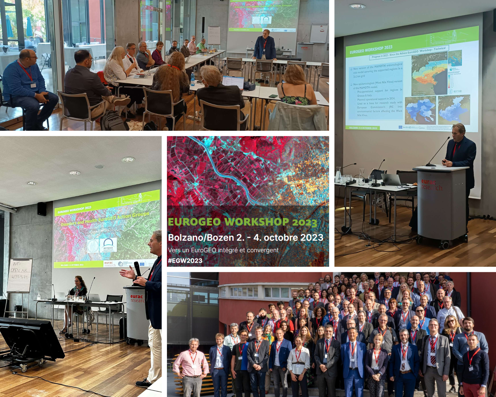
The Operational Unit BEYOND of IAASARS/NOA had an elevated presence in EuroGEO Workshop 2023 organizing three (3) sessions.
In particular:


Parallel session “EuroGEO Action Groups Disasters & Health”, 2/10/23

Dr. Haris Kontoes, Research Director of National Observatory of Athens (NOA) and Scientific Director of the Operational Unit BEYOND of IAASARS/NOA introduced the EuroGEO Action Groups Disasters & Health and chaired an open discussion with the participants. Interesting feedback was collected regarding the link of EuroGEO with national activities, as well as the contribution of EuroGEO to the GEO Community and the GEO-post 2025 strategy.
The Chairpersons had the opportunity to collect the key focus points from the session regarding how their session focus area and speakers presented expertise that can support the EuroGeo Community at large and the Post Geo 2025 Strategy. This input will be consolidated into two outputs lead by the JRC; an event report and a Ministerial Brief will be presented at the GeoWeek Ministerial Week in Cape Town.


Parallel session “Addressing climate-induced disasters and health challenges: The contribution of EuroGEO and GEO-CRADLE initiatives and the way forward”, 3/10/23

This session aimed at supporting sustainable development through the integration of Earth Observations in user-oriented and co-designed services for addressing climate induced disasters and health issues. In particular, the session focused on:

  • Showcasing success stories supported by EuroGEO (e-shape, as well as the Disasters and Health Action Groups) and GEO-CRADLE initiatives.
  • Reporting on the scientific/service progress of relevant Actions Groups and relevant communities.
  • Defining concrete roadmaps towards long-term sustainability of the on-going actions and services.
  • Promoting full and open access to EO data and science, and showcase business models for exploiting/sustaining the generated knowledge and services for the benefit of cross-sector stakeholders and communities with varying needs.
  • Designing future joint actions (e.g. policy papers / publications / special editions in journals / workshops / webinars / information days for applications and services) with the support of the EuroGEO Secretariat and relevant CSAs (e.g. GEO-CRADLE, COERNICUS FPCUP, GEOHEALTH, etc).
  • Creating synergies for long-term impact on GEO post 2025 strategy to address global climate-induced disasters and health crises.

Dr. Haris Kontoes chaired the session, which included 8 presentations and a round table discussion with the speakers. He presented “EYWA: Early Warning System for Mosquito-Borne Diseases” and Alexia Tsouni, Research Associate of Operational Unit BEYOND of IAASARS/NOA presented “GEO-CRADLE: GEO Capacity Building in North Africa, Middle East, Balkans and Black Sea Region”. A constructive discussion followed, and its key points were reported to the plenary the next day.


World Café “Shaping EuroGEO: Synergies and links between EuroGEO, Copernicus, and national GEO activities”, 4/10/23

This session aimed at discussing the strategic orientations for EuroGEO and the work of the EuroGEO secretariat in the future. More specifically, the discussion was focused on the needs and concerns of the Action Groups, with regards to receiving advice and counselling. Alexia Tsouni who chaired this session, collected inputs towards further improving the synergies and links between EuroGEO, Copernicus and national GEO activities. Achievements, challenges and the way forward were identified. The key points of the discussion were reported to the plenary the same day.


After 3 interesting sessions, more than 100 participants engaged with the GEO-CRADLE GEO initiative as well as with the EuroGEO Action Groups Disasters & Health through fruitful discussions and networking.

More Info: https://egw2023.eurac.edu/

#EGW2023


C0 SEISMIC1CO SEISMIC2

Δορυφορική συμβολομετρική απεικόνιση του πεδίου εδαφικής παραμόρφωσης από τον σεισμό στο Αφγανιστάν (7 Οκτωβρίου 2023).
 
Ισχυρός σεισμός πραγματοποιήθηκε στο Αφγανιστάν στις 7 Οκτωβρίου 2023, Μ6.2, 06:41:07 UTC. Η υπηρεσία geObservatory της Επιχειρησιακής Μονάδας BEYOND του ΙΑΑΔΕΤ/ΕΑΑ, αμέσως ενεργοποιήθηκε και κατέγραψε την εδαφική παραμόρφωση που προκλήθηκε από τον σεισμό. Συμβολογράφημα ανοδικής και καθοδικής τροχιάς δορυφόρου δημιουργήθηκαν αυτόματα από την πλατφόρμα geObservatory. Στα συμβολογραφήματα, παρουσιάζεται η εδαφική παραμόρφωση που προκλήθηκε από τον σεισμό. Κάθε κροσσός συμβολής, που παρουσιάζεται στο συμβολογράφημα, αντιστοιχεί σε εδαφική παραμόρφωση ίση με 2.8 εκ. Όλα τα διαφορικά συμβολογράμματα που σχετίζονται με τον σεισμό, θα είναι διαθέσιμα στην ιστοσελίδα του geΟbsevatory (http://geobservatory.beyond-eocenter.eu/), η οποία θα επικαιροποιείται, μόλις γίνονται διαθέσιμες νέες εικόνες Sentinel-1.


Co-seismic interferograms of Western Afghanistan earthquake, October 7, 2023

An M6.2 earthquake occurred in Western Afghanistan in October 7, 2023, 06:41:07 UTC. The geObservatory service of the Operational Unit BEYOND Center for Earth Observation Research and Satellite Remote Sensing of the Institute of Astronomy and Astrophysics, Space Applications and Remote Sensing of the National Observatory of Athens, was activated by the earthquake and mapped co-seismic deformation. Co-seismic interferograms of ascending and descending satellite passes were automatically produced. In the co-seismic interferograms, fringes present the surface deformation in the line of sight direction, induced by the earthquake. Each fringe, corresponds to a ground deformation equal to 2.8 cm. All co-seismic and pre-seismic interferograms, associated with the event will be freely available in the geObsevatory website (http://geobservatory.beyond-eocenter.eu/), which will be continuously updated, as soon as new Sentinel-1 images become available.


unnamed

The Operational Unit BEYOND Center ( http://www.beyond-eocenter.eu/ ) for Earth Observation Research and Satellite Remote Sensing of the Institute of Astronomy and Astrophysics, Space Applications and Remote Sensing of the National Observatory of Athens is seeking to hire a highly skilled and motivated DevOps Engineer to join our team, contributing to cutting-edge applied research at the intersection of Earth Observation data and Artificial Intelligence (AI) solutions.